THE WHEATLEIGH PLANS — FIVE
What Was There Before
A hundred and sixty-five acres, two buildings, a burying ground, and a boundary cornered on an American chestnut. The Olmsted office drew Wheatleigh straight on top of it.
The first sheet in the Olmsted firm's file for Wheatleigh is not a design. It is a farm survey, made seven years before Henry H. Cook hired anyone, by a surveyor from Housatonic who had no idea what was coming.
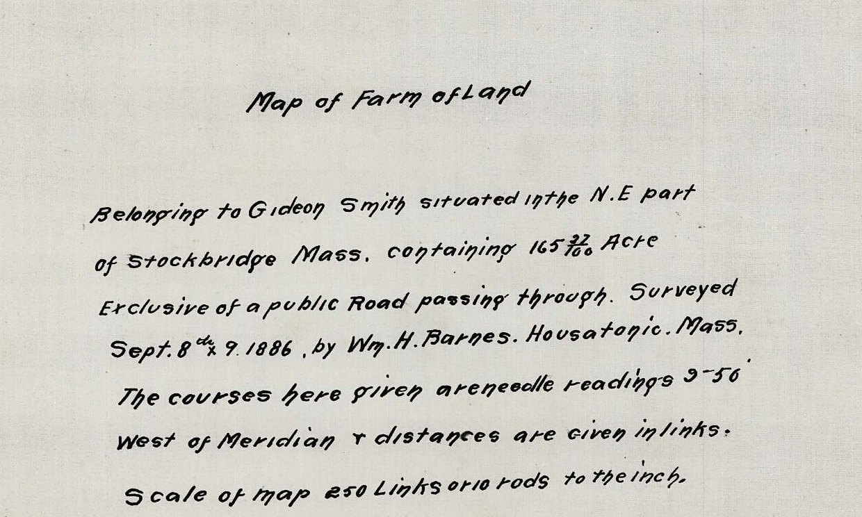
It reads, in full:
“Map of Farm of Land / Belonging to Gideon Smith situated in the N.E. part of Stockbridge Mass. containing 165 27/100 Acre Exclusive of a public Road passing through. Surveyed Sept. 8th & 9th 1886, by Wm. H. Barnes, Housatonic, Mass. The courses here given are needle readings 3°50' West of Meridian & distances are given in links. Scale of map 250 Links or 10 rods to the inch.”
Two days' work in September 1886. It arrives at the Olmsted office in Brookline on 25 January 1893 and carries the receipt stamp in the corner.
I The Farm, in Ink
Two buildings are drawn in heavy ink at the north end, near the road: an L-shaped house with an ell, and a long rectangular barn to the south-west of it, sitting among scattered trees with a loop of drive between them.
The boundary runs to named neighbors — J.E. Parsons on the north-west, D.W. Bishop, W.D. Sloane's land to the east, Henry Horsford's and Wm. Morrell's to the south. The water is Stockbridge Pond on the west and, at the north-east corner, Lilly Lake, drawn with marsh.
The corners of the property are trees. A chestnut. A white birch. A soft maple, marked. A stake in marsh. Stakes and stones. That is how a farm was fixed in place in 1886 — you walked to a tree and cut a blaze in it, and the tree held the line.
It is worth stopping on the chestnut. A property corner witnessed by an American chestnut, fifty years before the blight took every mature one in the country. The monument outlived the surveyor and then it died of something nobody had heard of.
II And Wheatleigh, in Pencil
Somebody in Brookline put a pencil to this sheet.
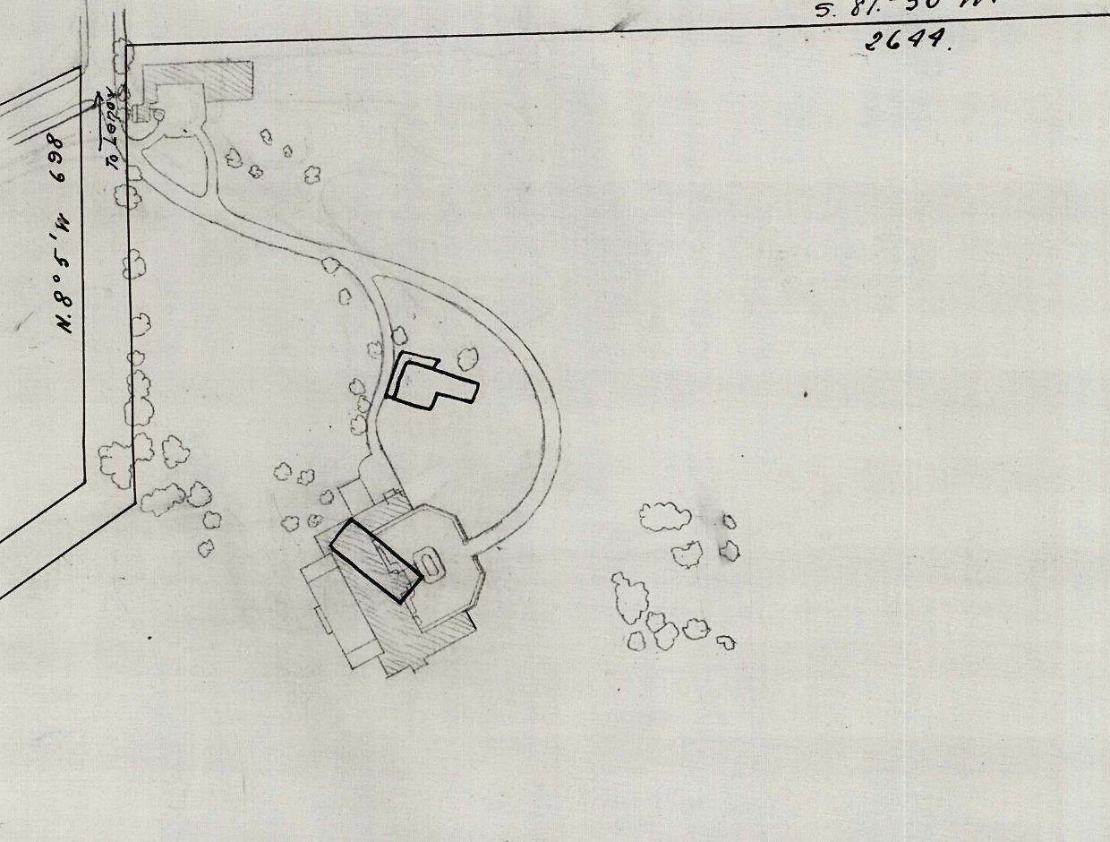
Over the ink farm, in graphite, is the whole scheme: the mansion footprint with its terrace, the circular forecourt, the long curve of the approach drive, a gate lodge set on the road at the top, and trees dotted across the lawn. The archive's own note on the sheet reads “House & Lodge in graphite over existing buildings.”
The two drawings are a foot apart on the same piece of paper. The barn stands roughly where the west end of the house goes.
III What Kind of Ground It Was
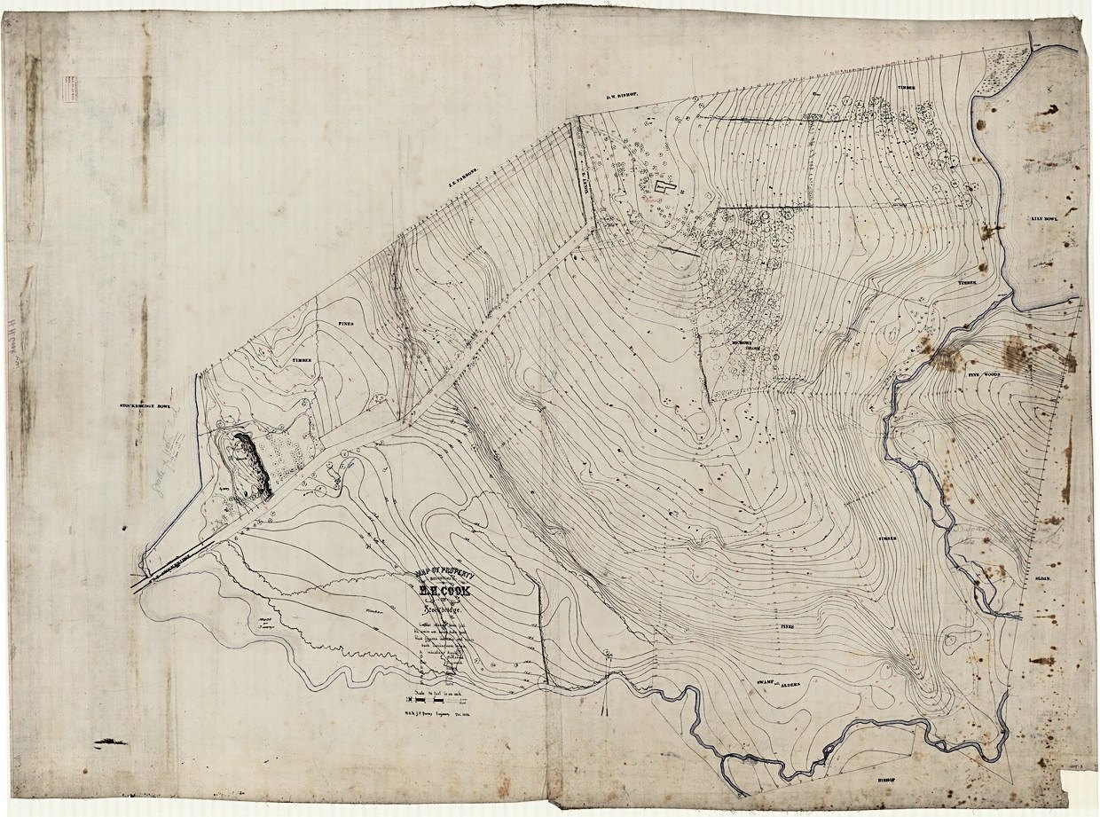
The December 1892 survey is the one that says what the place actually was. Contours across the whole property, brooks inked in blue, and the cover written across it in block capitals as the surveyors found it: TIMBER in four separate places, PINES, PINE WOODS, HICKORY GROVE, SWAMP with ALDERS, Marsh and Swamp, Meadow. STOCKBRIDGE BOWL on the west edge. LILY BOWL on the north-east.
Not a park. A working hill farm with woodlots, a sugar bush, wet ground at the bottom and pasture in between.
IV Down to the Individual Tree
By July 1893 the surveying gets finer. The Lenox parcel — 50.43 acres including road, the road itself 1.75 — is drawn at three-foot contours with every run of stone wall written in and the ground described as found: Low Ground with Timber, Maple Sugar, Shady Rock Pit and Bushes.
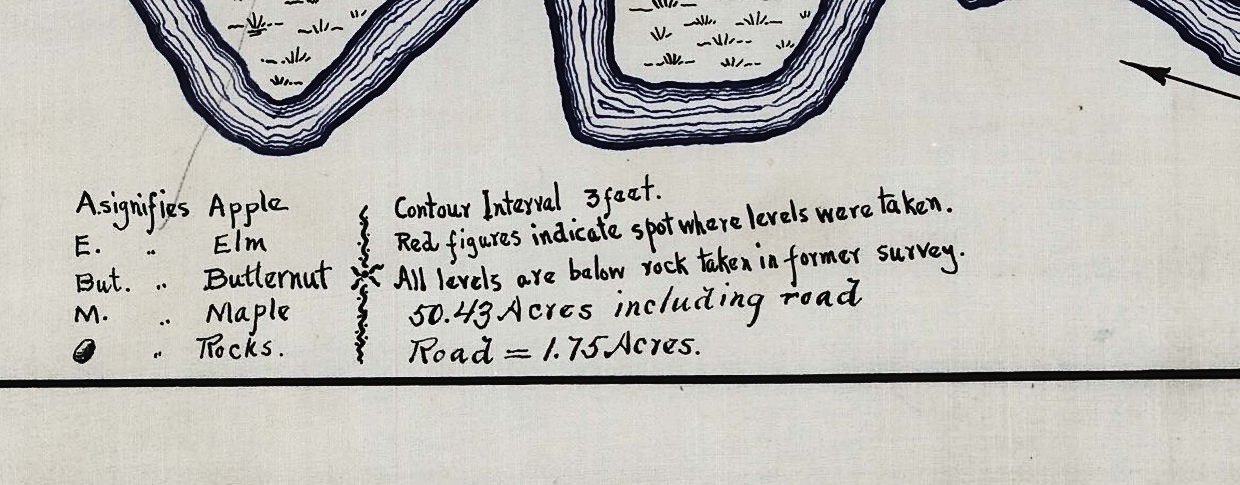
And the trees are keyed individually, by species, each with a spot elevation. Apple, elm, butternut, maple. Somebody walked that ground and wrote down where every orchard tree and every dooryard elm stood, because a banker in New York needed to know what he had bought.
That key is the reason a large tree at Wheatleigh today is an answerable question rather than a guess. It was either planted by the Olmsted office after 1893 or it was standing when the Barnes brothers came through — and this sheet is how you tell.
V The Other Farmstead
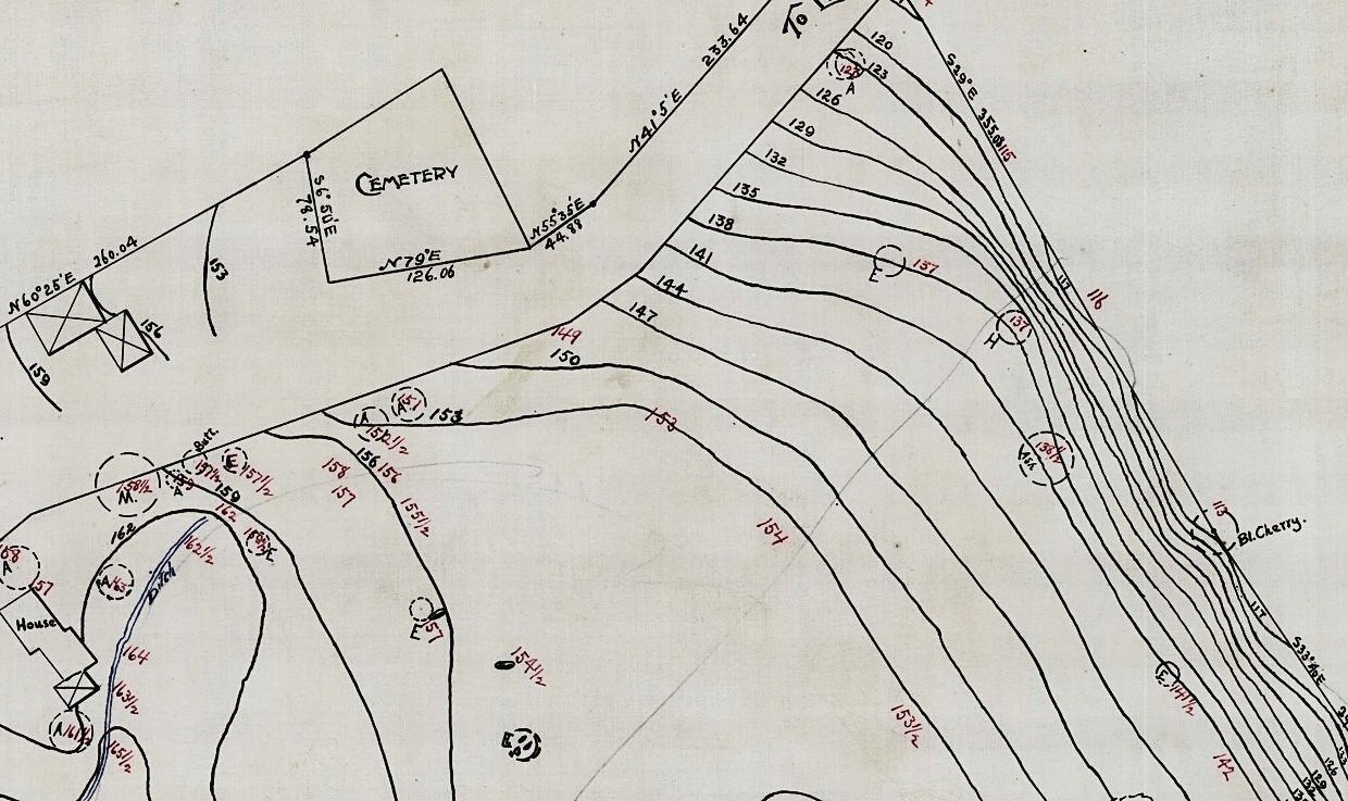
At the far end of the property, on the road line beside the burying ground, the same survey shows two more buildings crossed through in the surveyor's convention. Below them a House with a wing, a Well, and a Ditch inked in blue.
So there were at least two building groups on this land before Cook: the house and barn at the north end, and this cluster at the south. Neither survives.
VI And the Road
The public way through the property is on the 1886 survey as an existing fact — the farm's acreage is given “exclusive of a public Road passing through,” with 26 27/100 acres lying west of it.
In September 1893 Cook had it moved. Three sheets in five days: field levels, a map of the new road laid out for an old one to be discontinued, and a relocation plan signed by the same W.H. Barnes who had surveyed the Smith farm seven years earlier, now working out of the Olmsted office.
The surveyor who measured the farm helped move the road off it. That is the whole transition in one man's signature.
VII What Was Kept
The fields went to lawn and woodland belt. The farmhouse went. The barn went. The buildings by the cemetery went. The road moved. The name on the deed changed from a Connecticut settler's grandson to a New York railroad fortune, and the place got an English name.
One thing on the property was measured, bounded, drawn on every general plan, and left exactly where it was: the burying ground. The contours run up to its fence and stop.
Nobody was left to insist on it.
Sources: Olmsted Archives, Frederick Law Olmsted National Historic Site, job #01295, plans 1, 3, 3-A, 5, 12, 20, 31, 53 and 54. Images courtesy of the United States Department of the Interior, National Park Service, Frederick Law Olmsted National Historic Site.