THE WHEATLEIGH PLANS — FOUR
The Burying Ground That Nobody Owns
A Stockbridge farm family stopped burying their dead here around 1850. Forty years later the most famous landscape office in America measured the plot to the inch and drew a line around it. Today the town mows it.
Before Wheatleigh there was a farm, and the first drawing in the Olmsted firm's file for the estate is not a design at all. It is somebody else's survey.
| Date | Sheet | What it is |
|---|---|---|
| Sep. 8, 1886 | Plan 1 | “Map of a Farm of Land Belonging to Gideon Smith, Situated in N.E. Part of Stockbridge.” 165.27 acres. Received at the Olmsted office in Brookline on Jan. 25, 1893. |
| July 1893 | Plan 31 | The Barnes brothers survey the property at three-foot contours. The burying ground is measured as its own parcel, with bearings and distances. |
| Oct. 31, 1893 | Plan 75 | General plan of the estate. The graveyard is drawn in place. |
| Aug. 17, 1894 | Plan 119 | General Plan of Estate. The parcel is lettered GRAVE-YARD, and the planting runs down both sides of the road past it. |
Henry H. Cook did not buy a landscape. He bought parcels, and one of them was the Gideon Smith farm — a hundred and sixty-five acres in the northeast corner of Stockbridge, surveyed in 1886 by W.H. Barnes of Housatonic and carried into the Brookline drafting room in January 1893 with a house and a lodge pencilled in over the buildings that were already standing on it.
Gideon Smith took that land in the 1760s, when the end of the French and Indian wars made it possible to build something in these hills and expect to still be standing in the morning. His family farmed it for three generations and buried their dead at the top of the slope, on a rise above the water. No stone in that plot is dated past about 1850.
I What the Survey Caught
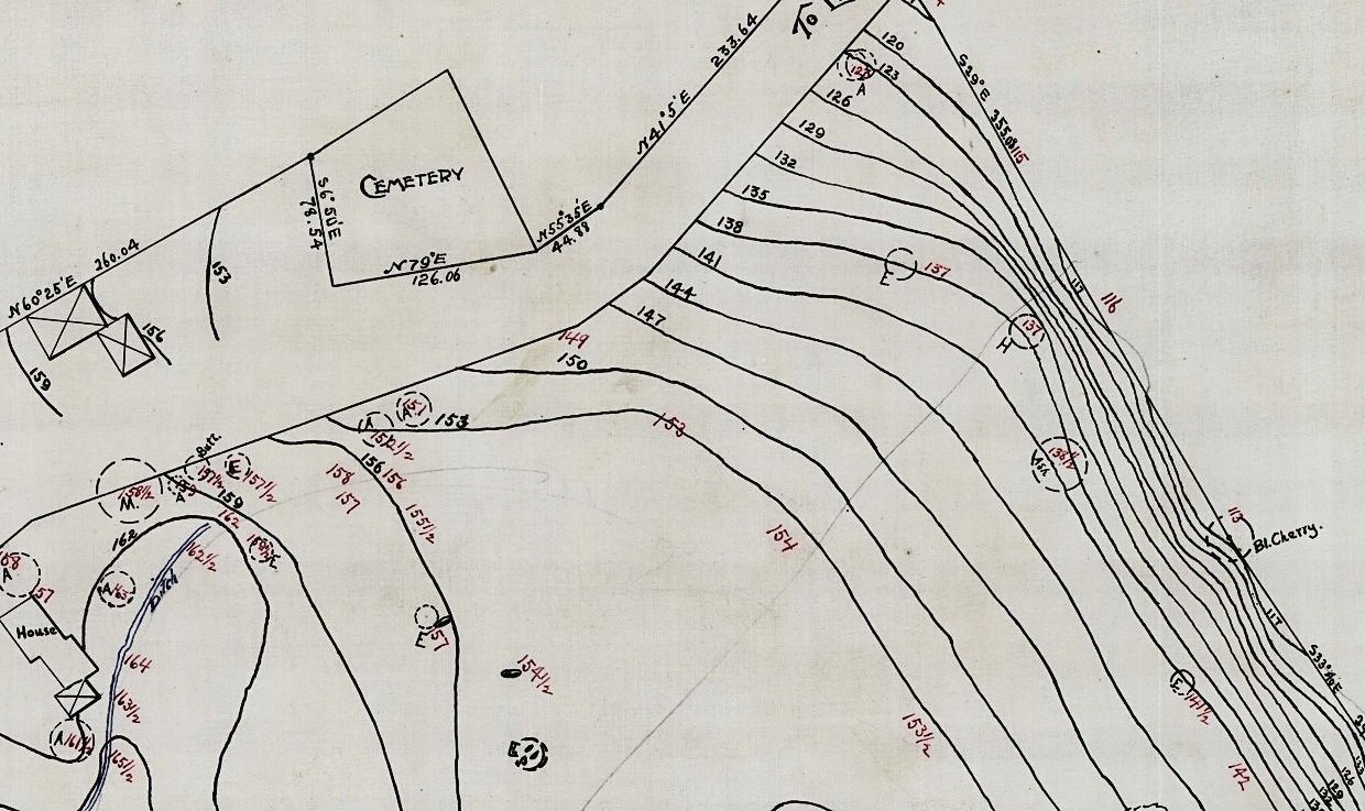
The July 1893 survey is the last picture of the farm as a farm, and it is extraordinarily detailed. Three-foot contours across the whole property. Every run of stone wall written in. The ground keyed as it was found — Low Ground with Timber, Maple Sugar, Shady Rock Pit and Bushes. Individual trees marked with a letter and a spot elevation: A for apple, E for elm, But for butternut, M for maple. The dooryard and the orchard of a working farm, recorded because a New York banker needed to know what he had bought.
Southwest of the burying ground, hard on the road line, two buildings are drawn in the surveyor's crossed-square convention. Below them a House with a wing, a Well, and a Ditch inked in blue.
None of it survives.
II What the Office Did With It
The burying ground is measured as a discrete parcel, with its own bearings and distances written along each side — S6°50'E, 78.54 feet; N79°E, 126.06; N55°35'E, 44.88. It sits on the property line.
And the contours stop at its edge. The surveyor ran levels across the entire farm and did not run them inside the fence.
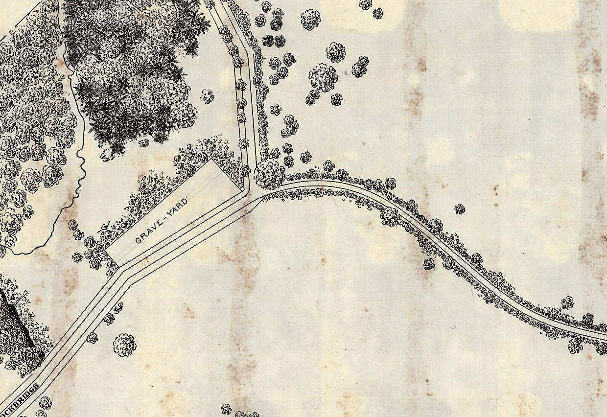
By the General Plan of August 1894 the parcel is simply lettered GRAVE-YARD, and the estate's planting is carried down both sides of the road that passes it. Olmsted, Olmsted & Eliot redrew a hundred and sixty-five acres of somebody else's fields into a pastoral park, moved a public highway to do it, and left the graves exactly where they were.
It would have been easy not to. Nobody was left to object.
III The Mound
The plot sits on a steep rise of about a hundred feet square, graves on top of it. It has the abrupt, out-of-place look of something dumped there, which is the usual look of a kame — a mound of sand and gravel left where meltwater ran out at the edge of the retreating ice. Ice-contact deposits like it run all through the Housatonic basin, and Stockbridge Bowl below is itself a kettle.
Which is exactly why anyone would bury on it. Sand and gravel drain, and a rise above water is the driest ground in the neighborhood.
IV Whose Is It Now
It is no longer part of Wheatleigh. It is not clear that it is part of anything. No owner presents himself, and the town keeps it mown.
Massachusetts anticipated this. Ground that has served as a burial place for more than a hundred years cannot be sold off or turned to another use, and no part of one may be taken for public purposes without the Legislature saying so. The protection does not depend on anyone holding a deed, and it reaches unmarked ground as well as stones.
So the practical position is that a quarter-acre of Stockbridge belongs to whoever is buried in it, all of whom are dead, and is looked after by the town, which may or may not own it, under a law that says it cannot be anything else.
That is a more secure arrangement than most things have.
V Who Is Actually in It
The plot carries Gideon Smith's name, it sits on Gideon Smith's farm, and it is the Gideon Smith Cemetery in the public record. Which makes it easy to assume a family plot and stop there. The stones are less tidy than that.
One of them, photographed in September 2022, reads:
“In memory of / Miss Polly Bradner, / Daugr. of Mr. Colvill & / Anna Bradner. / of Warwick (N.Y.) / Deceas’d Nov. 7 1810. / Aged 21.”
Not a Smith. Not a Smith daughter who married a Bradner either — the stone says Miss, and names her father and mother. Polly Bradner was twenty-one years old and she was from Warwick, in Orange County, New York — across the state line.
The carver wrote the town out in full, which is not what you do for someone everybody knows. It reads like a stone cut for a stranger — a young woman who died away from home and was buried where she died.
Two other stones carry names that are not Smith either, and a double stone for two children gives dates in the 1840s. So this may be a family plot that took in visitors and neighbors, or it may be a neighborhood burying ground that happens to stand on the Smith farm and carry the Smith name. The stones as photographed do not settle it, and this article is not going to pretend otherwise. What they do settle is that the ground stopped being used around 1850, and that at least one person in it came a very long way to be here.
VI The Thing Worth Noticing
Wheatleigh's landscape is documented to a degree almost nothing of its period is — forty-seven drawings, a planting schedule with counts and spacings, a correspondence file running to 1919. The fields are gone. The farmhouse is gone. The tavern that stood on the old road is gone. The springhouse is gone. Two-thirds of the estate has been sold away in pieces.
The graveyard is still there, and it is still exactly the shape the Barnes brothers measured in July 1893 — because it was the one thing on the property that nobody was allowed to improve.
Sources: Olmsted Archives, Frederick Law Olmsted National Historic Site, job #01295, plans 1, 31, 75 and 119. The Massachusetts law on ancient burial places. Gravestone photographed on site, 26 September 2022. Plan images courtesy of the National Park Service.