I. Why these drawings are blue
Nearly everything in this story is a blueprint in the literal sense — white lines on Prussian blue, because that is what a cyanotype does.
A drawing was made once, in ink on tracing paper, by somebody at a bench. Copies were made by laying that tracing over paper coated in iron salts and putting the sandwich in the sun. Where light got through, the paper turned blue; where the ink blocked it, the paper stayed white and got washed out. It is a photographic process, invented in 1842, and it is the reason a design could be in twelve people’s hands at once by the 1890s instead of being copied out twelve times by twelve clerks.
So a blueprint is not the drawing. It is the drawing multiplied — the version that goes in a coat pocket, out to the site, into the rain, and back. These are working papers, and the reason they read so strangely well a century later is that they were written to be understood by a man standing in a field.
II. The hill is a drawn object
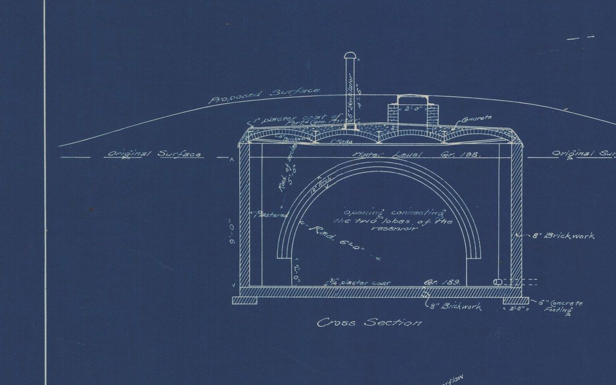
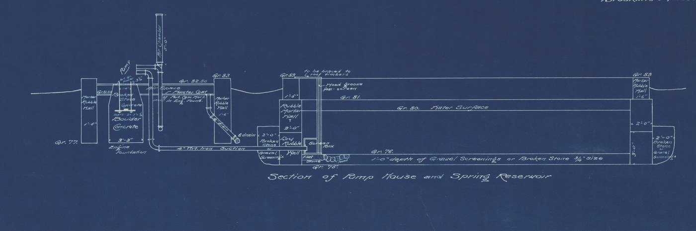
Look again at the reservoir section. There are two ground lines on it. One is labeled Original Surface. The other, curving above it, is labeled Proposed Surface.
That is the whole of the earthwork trade in two words. The ground these houses stand on is not the ground that was there. It was cut where it was too high, filled where it was too low, rounded off where it broke awkwardly, and then grassed so that the result would look like a hill that had always been that shape. The Olmsted office drew the new hill and somebody built it with barrows, scoops and horses.
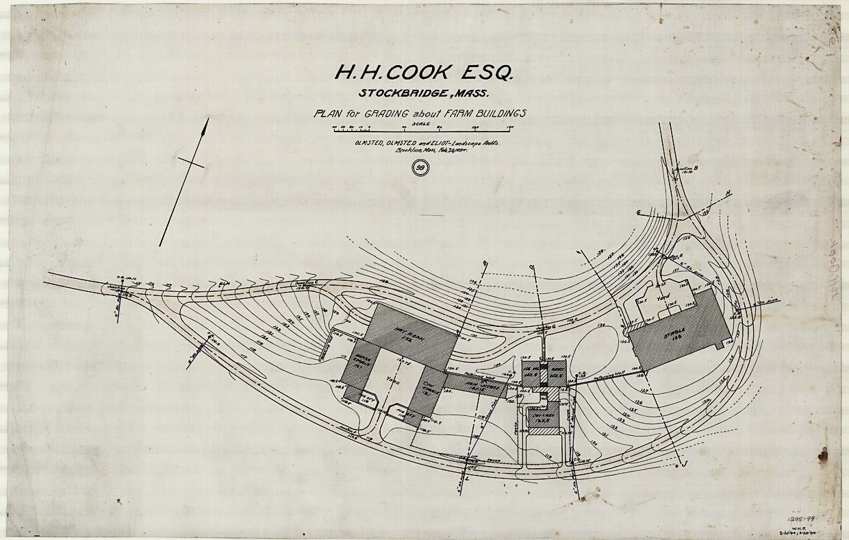
The grading plans for the Wheatleigh farm buildings run in sections lettered A to L — a dozen slices through one piece of ground, each one showing how far down or how far up the finished surface sits against what was there. Every inch between those two lines was moved by hand and by team.
III. Moving the road
Then there is the matter of the public highway.
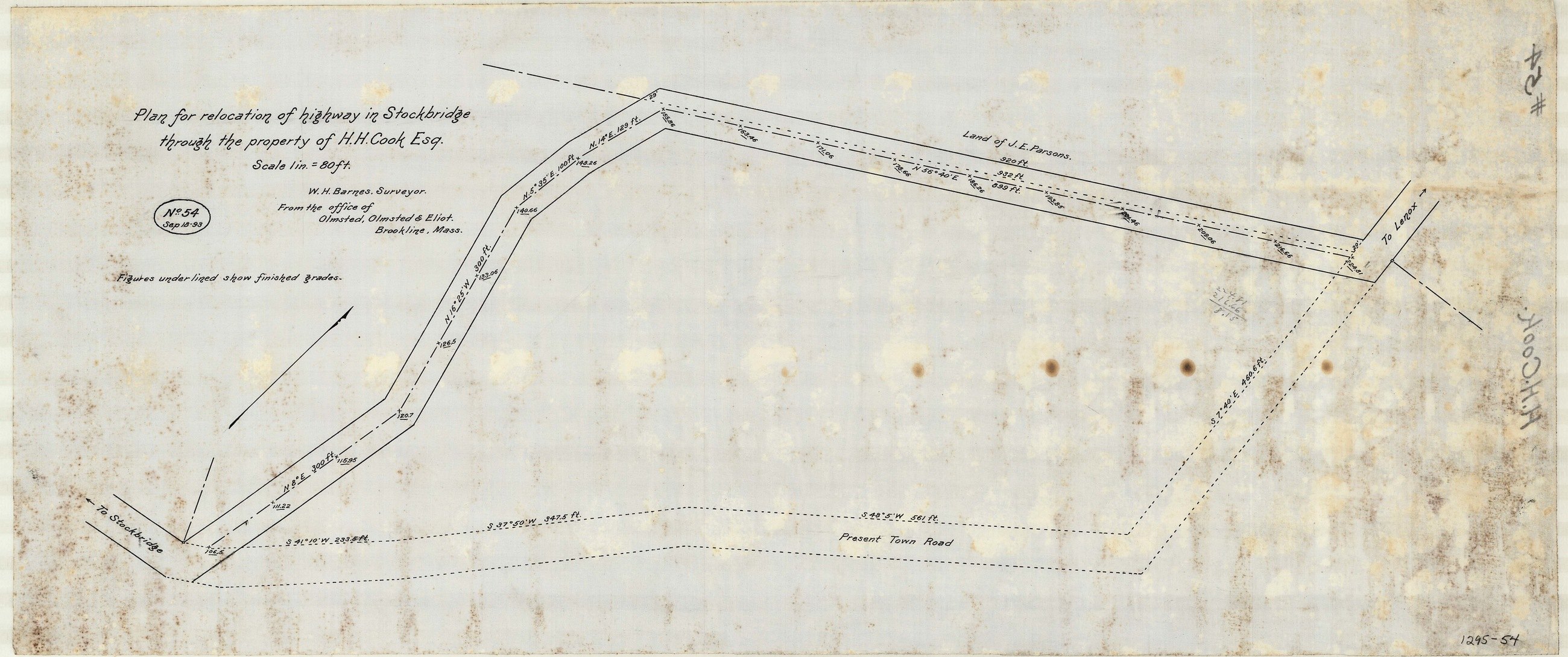
On 18 September 1893 the office produced a sheet showing the existing town road in dotted line and its replacement in solid line, swung north and uphill. The surveyor is named: W. H. Barnes, from the office of Olmsted, Olmsted & Eliot.
The road was in the wrong place. So the road moved.
It is worth pausing on what that involved — a town meeting, a vote, a layout, damages, and then the actual business of building a new piece of public highway across a hillside so that a private view would not be interrupted. The dotted line is where generations of people had driven a cart. The solid line is where they drive now.
IV. Finding the water
A house on a hill has no water. That is the defining problem of the site, and the Wheatleigh file solves it on two sheets with a precision that would let you rebuild the thing tomorrow.
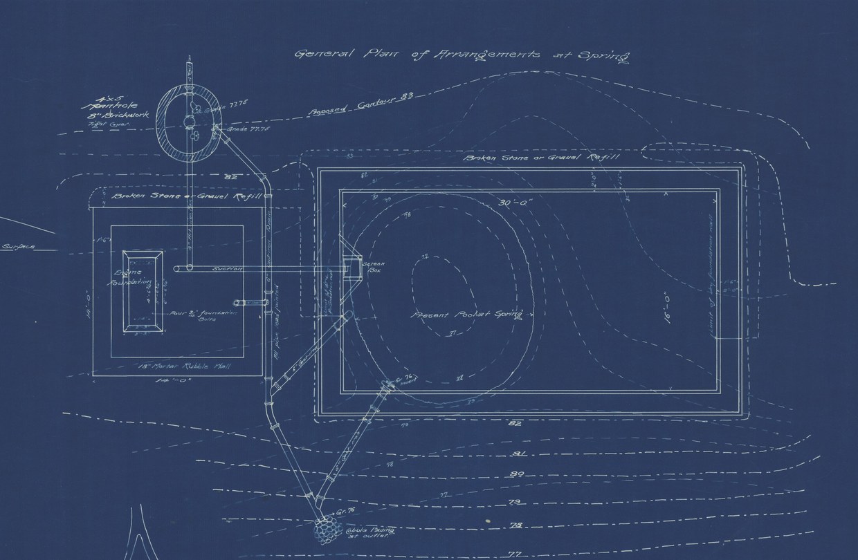
The first is headed General Plan of Arrangements at Spring. It shows a pool at a natural spring, thirty feet across, with the contours of the hollow drawn in around it — 76, 77, 78, on up to the proposed contour 83. The existing water is labeled, in the office’s careful lettering, Present Pool at Spring.
Around that pool the drawing arranges an entire small waterworks. A screen box, to keep the leaves out. A six-inch cast-iron suction line, with the note that all pipe is to be lead jointed. A manhole four feet by five, in eight-inch brickwork, with a tight cover, its rim at grade 77.75 — measured to the hundredth of a foot. Cobble paving at the outlet, at grade 76, so that the overflow would not cut a gully. And a pump house: fourteen feet square inside an eighteen-inch mortar rubble wall, with an engine foundation in the middle of it held down by four three-quarter-inch bolts.
Four bolts. Specified, drawn and dimensioned on a landscape architect’s sheet, because in 1893 the landscape office was the engineering office too.
V. Twenty-five thousand gallons, buried
The second sheet is the reservoir, and it is the best drawing in the file.
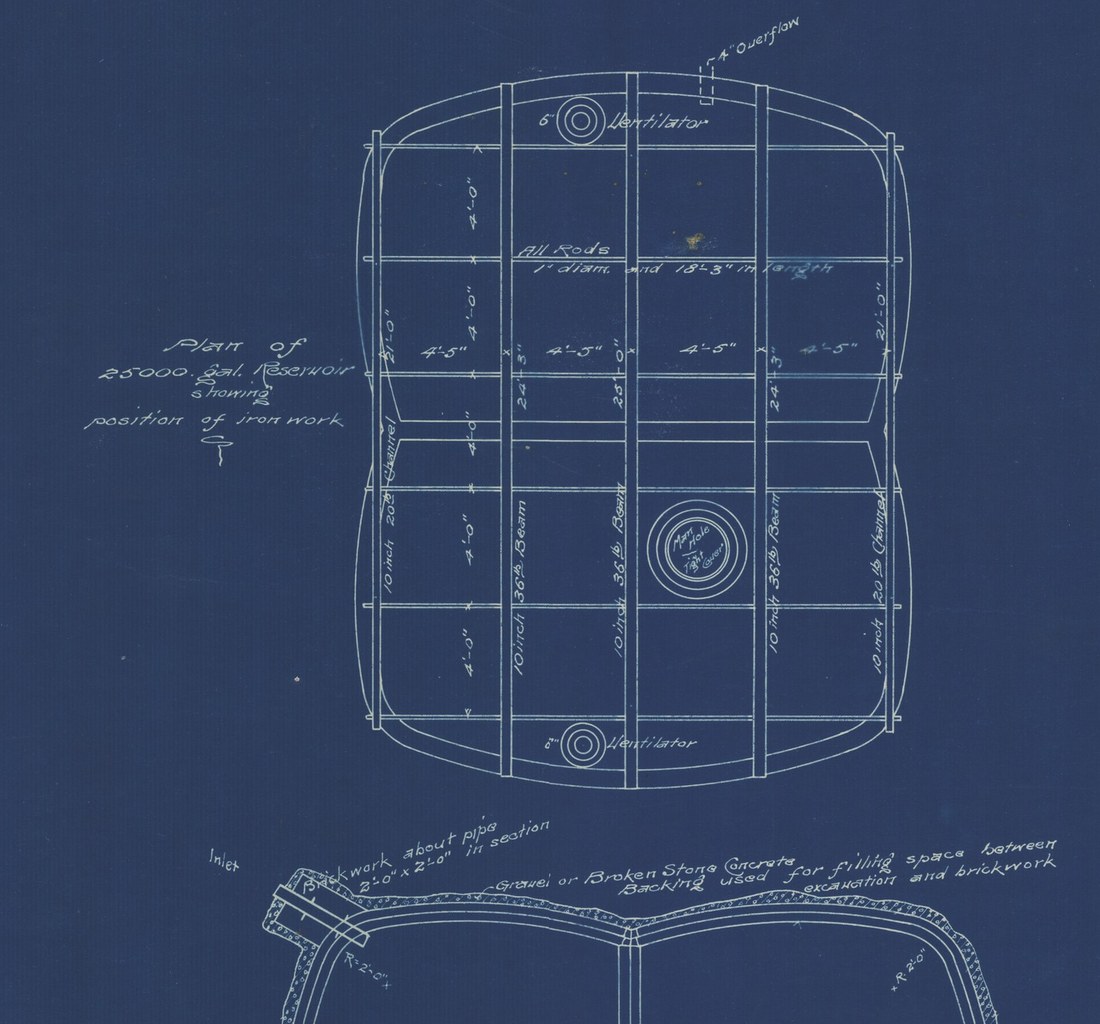
It holds twenty-five thousand gallons. It is built of brick — eight-inch walls, a twelve-inch arch, struck to a radius of six feet — in two barrel-vaulted lobes side by side, with, as the section says in so many words, an opening connecting the two lobes of the reservoir. Inside, it is nine feet from floor to springing. The floor takes a three-quarter-inch plaster coat over eight-inch brickwork on a six-inch concrete footing. The crown gets a one-inch plaster coat of Portland cement. The two vaults are tied together with iron rods an inch in diameter and eighteen feet three inches long, and the plan sheet exists for no other purpose than to show where those rods go: Plan of 25000 Gal. Reservoir showing position of iron work.
Then a manhole shaft in brickwork, two feet square. Two ventilators standing four and a half feet clear. An inlet, an overflow, brickwork two feet by two feet in section carried around the pipe where it passes through the wall, and broken stone concrete rammed into the gap between the brickwork and the sides of the excavation.
And over the top of all of it, the Proposed Surface — a smooth curve of new ground, so that when the grass took, there would be nothing on that hillside but a slight rise and two little pipes.
VI. The lift
Now put the two sheets side by side.
The spring works at grades in the seventies. The reservoir sets its water level at grade 198 and its floor at 189. These are figures above an assumed base, in the manner of the whole job, and both sheets come out of the same file — so the arithmetic is what it looks like. The engine at the bottom of the hollow had to lift the household’s water something on the order of a hundred and twenty feet, all day, every day, into a brick chamber buried in a lawn.
Everything above that — the bathrooms, the laundry, the conservatory, the fountain in the forecourt, the hoses the gardeners ran out over the terrace in July — is downhill of the reservoir and runs on the head it provides. The system has no cleverness in it at all. It is a spring, a pump and a tank, executed at a scale and a tolerance that a town waterworks would recognize, for one family and its staff.
VII. The other answer: a tank on a frame
Bury it, or build it. Thirty miles north, the same office solved the same problem the opposite way.
Wirt Dexter Walker — a Chicago lawyer going blind, who had bought four hundred and fifty acres above Pittsfield to get well in — needed a head of water at Blythewood. A hilltop house with no town main has two options: a buried reservoir higher than the house, or a tank up in the air. Walker got the tank.
What is remarkable is what the Olmsted office then did with it. Seventy-seven sheets survive for the whole estate, and nine of them are the water tower. Elevations. Octagonal framing plans worked out at three levels. Sections. A sheet of plans on pink paper. Two more locating it on the ground with the drive running past. And, on 19 May 1893, this:
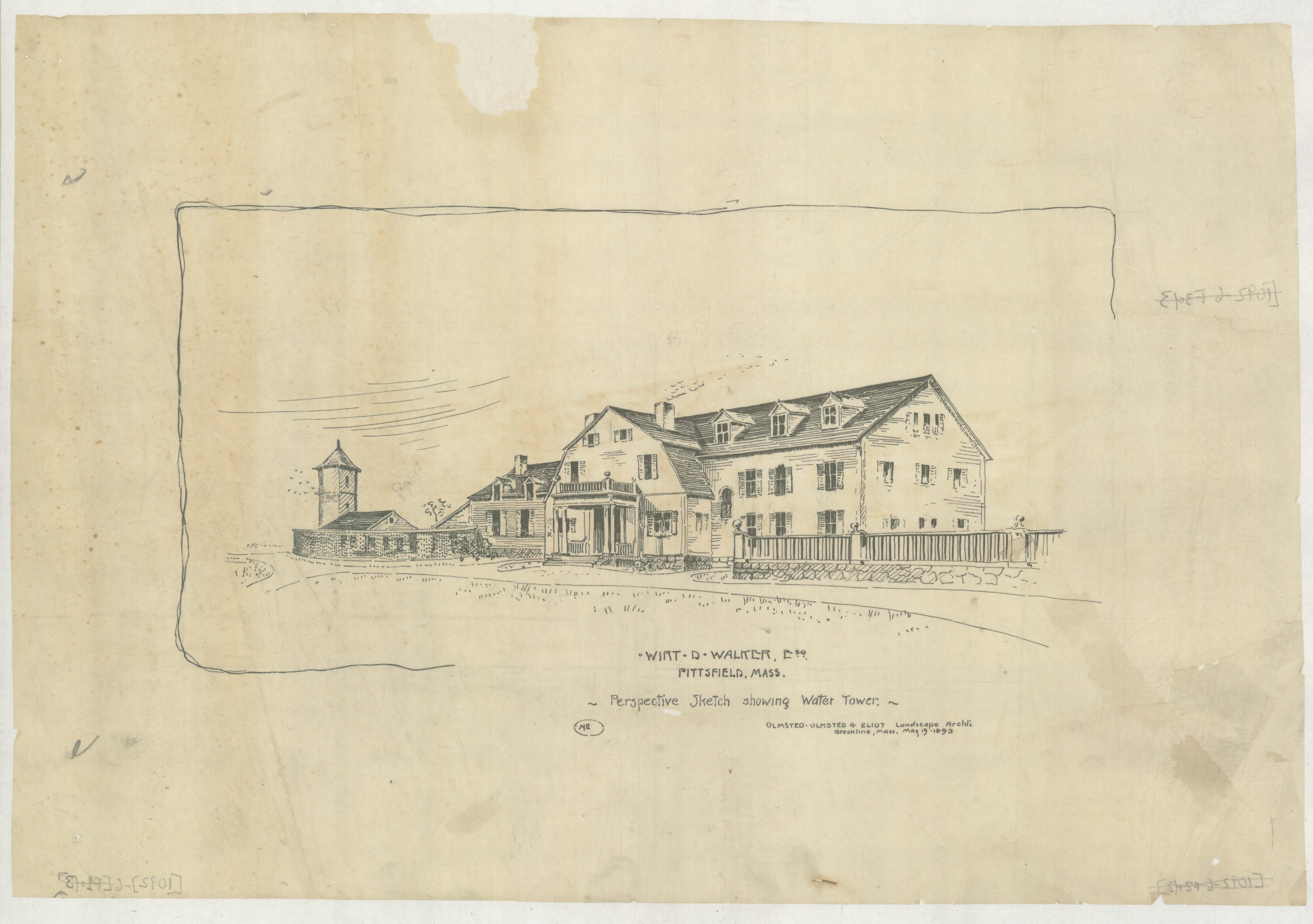
A perspective sketch. Of a water tank. Set in the landscape, with the house behind it, so that the client could see what he would be looking at.
The thing they drew is shingled and half-timbered with a lantern on top — a tank dressed as a building, and a rather good building. The office could have written tank on a plan and moved on. Instead somebody in Brookline decided that the one structure this estate could not do without was going to be worth looking at, and spent nine sheets making sure of it.
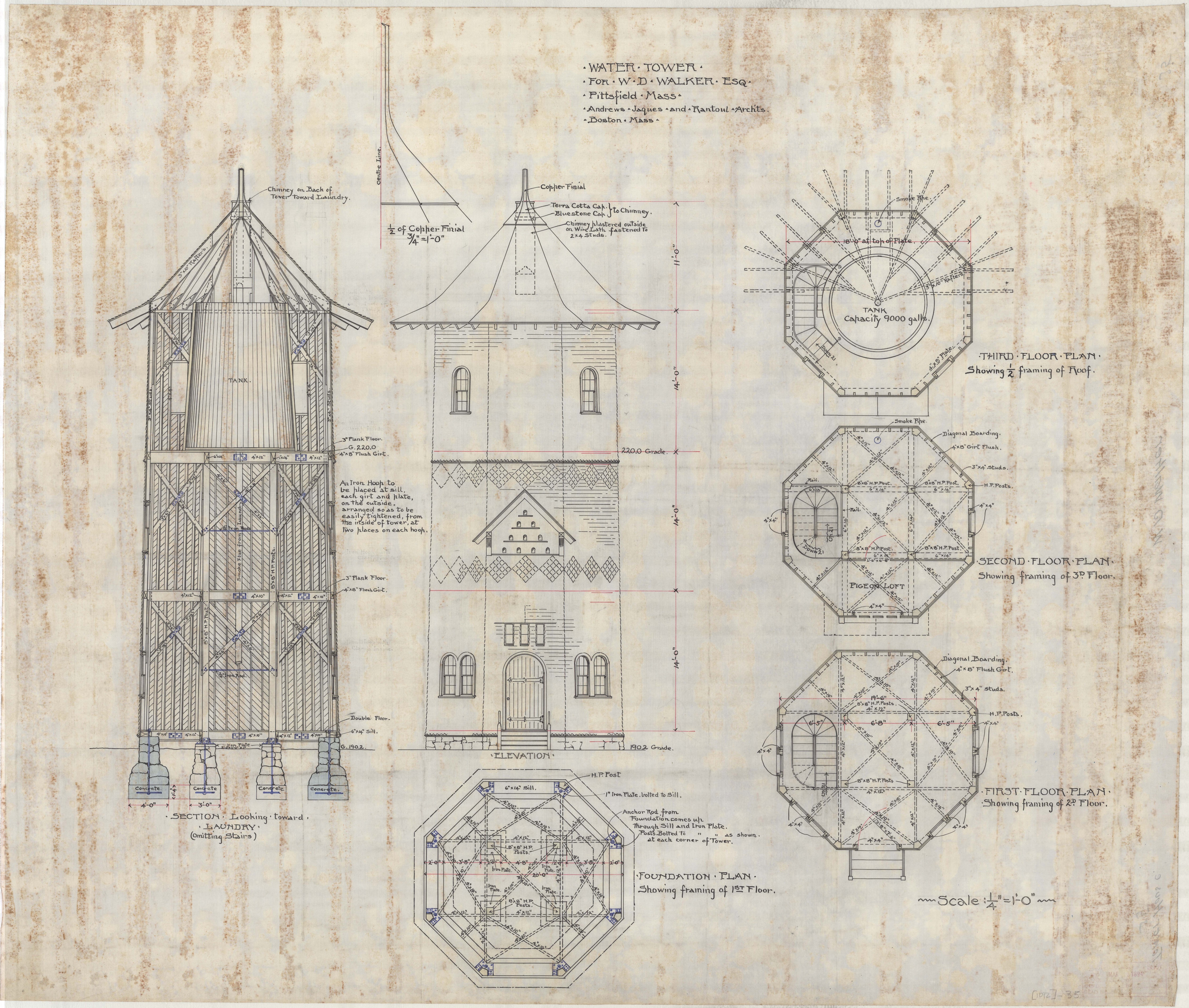
Set the two side by side and you have the whole argument of this section in two drawings. At Wheatleigh the waterworks is a brick chamber in a hole with the grass pulled over it, and nobody was ever meant to know it was there. At Blythewood it is eight posts, three tiers of bracing and a lantern, standing in the view on purpose.
Both were drawn by the same firm, in the same eighteen months, for clients four towns apart. Both were built by men with barrows and handsaws. One of them got a perspective sketch.
VIII. Who actually did it
Nobody on any of these sheets.
Excavation in 1893 meant pick, shovel, barrow, plank run and horse scoop. A buried reservoir of this size means a hole perhaps forty feet across and twelve deep, cut into a hillside, kept from falling in, and then backfilled and graded over. The spring works means a second excavation at the bottom of a wet hollow, in wet ground, by hand. The road means a third. And all of it had to be done in the season, between the frost going out and the frost coming back, because you cannot dig a Berkshire hillside in February and you cannot lay brick in it either.
The directory that covers these towns thirty years later still counts two hundred and ninety-six laborers and eighty-two teamsters in ten towns, alongside three hundred farmhands. They are the same trade. A man with a pair of horses and a scoop was the earth-moving industry, and he is in the record as a name, a street and the word laborer, with no indication whatever of which hillsides he moved.
IX. Still there
The interesting thing about all this work is that it was built to be invisible and mostly succeeded.
The house is famous. The terrace is photographed. The reservoir has no photograph at all, because there was never anything to photograph: it went into the ground finished, and the ground went over it, and the grass went over that. Brick chambers of this kind are not demolished when they stop being used. They are disconnected and forgotten, and the lawn goes on being mown above them.
Which means the most completely documented single structure in this entire section — dimensioned, specified down to the diameter of a rod and the size of a stone — is also the one nobody has ever seen.
All drawings from Olmsted job 01295 (Wheatleigh), Olmsted Archives, Frederick Law Olmsted National Historic Site, National Park Service. Titles, dimensions, grades and notes are quoted exactly as lettered on the sheets, including “Plan of 25000 Gal. Reservoir showing position of iron work,” “General Plan of Arrangements at Spring,” “Present Pool at Spring” and “opening connecting the two lobes of the reservoir.” Grade figures are above an assumed base, as the job’s own survey notes state. The road plan of 18 September 1893 names W. H. Barnes as surveyor. Trade counts from Crowley & Lunt, South Berkshire Directory, 1923–’25, reproduced in full here; that volume does not cover Lenox, which is in the 1926 Central Berkshire directory instead. Sheet-by-sheet listings for this job are on the Wheatleigh page.