The most useful thing on plate 2 of the Barnes & Farnham atlas is a small pink wedge in the angle between two railroads, lettered UNION DEPOT. It is the 1866 building. Ten years after the sheet was drawn it came down — and the hotel drawn immediately beside it, BURBANK HOUSE in yellow for wood, went first. The railroad bought that property, built the new station on it, and razed the old depot once the new one was finished. Neither site holds a railroad station now. Plate 2 is the densest sheet in the atlas, 861 separate entries, and it is very largely a record of things that are gone.
I. An act to close a street
The building begins as a statute. Acts and Resolves Passed by the General Court of Massachusetts for 1866, chapter 126, approved 7 April 1866, is headed:
“AN ACT TO UNITE THE PASSENGER STATIONS OF THE WESTERN RAILROAD CORPORATION AND THE STOCKBRIDGE AND PITTSFIELD RAILROAD CORPORATION IN THE TOWN OF PITTSFIELD, AND TO CHANGE THE LOCATION OF WEST STREET, IN SAID TOWN, FOR THAT PURPOSE.”
Read the title again. The street is being moved for that purpose. The act directs the county commissioners to change the location of West Street so that it passes under the tracks, running “until it reaches the south line of said street at some convenient point on the westerly declivity of Jubilee Hill, so called” — and then, on completion, to discontinue West Street where it crossed the railroad. Section 5 puts the station “at the point where West Street now crosses the Western Railroad.” Section 6 makes it the sole expense of the Western Railroad Corporation, to be occupied jointly, with the Stockbridge and Pittsfield paying “a reasonable rent.” Section 7 gives them three years to finish it.
Hold on to the name Jubilee Hill. It comes back in this story a hundred years later, on a different kind of document.
Smith’s history, printed ten years afterwards, tells it more briskly and not quite the same way:
“This statute required the closing of West street, by the erection of the depot across it, at a point about a quarter of a mile west of North street. It also required that the county-commissioners should lay a new street around the south end of the depot, and under the tracks of the two roads; this street to be built by the railroad-companies, to the satisfaction of the town.”
The quarter of a mile west of North Street is Smith’s measurement, not the act’s; so is “to the satisfaction of the town.” The act arranges the closing as a consequence, where Smith reads it as a requirement. Both are quoted here because both are what the source says.
Two companies in the statute and two in Smith, but they are not the same two. Smith gives it as built by the Boston and Albany with the Housatonic as equal-use tenants; the act names the Western and the Stockbridge and Pittsfield, and requires it to serve the Pittsfield and North Adams as well. Smith explains the first half himself, in a footnote: he has used the name Western throughout “as it was not until after the last event in their history, which it comes within our province to record, that the Western and the Boston and Worcester companies were consolidated as the Boston and Albany.” The Stockbridge and Pittsfield was the Housatonic’s leased line. Smith is describing the operating reality and the statute is naming the corporations, and the two are reconcilable — but three roads used the building, not two.
Of the building itself Smith writes that “here one of the most convenient and beautiful depots in the country was built.” That is his own judgment, in 1876, and not a quotation he is reporting; it has been passed along since as though it were contemporary praise.
II. The engraving, and the figures that are not in Smith
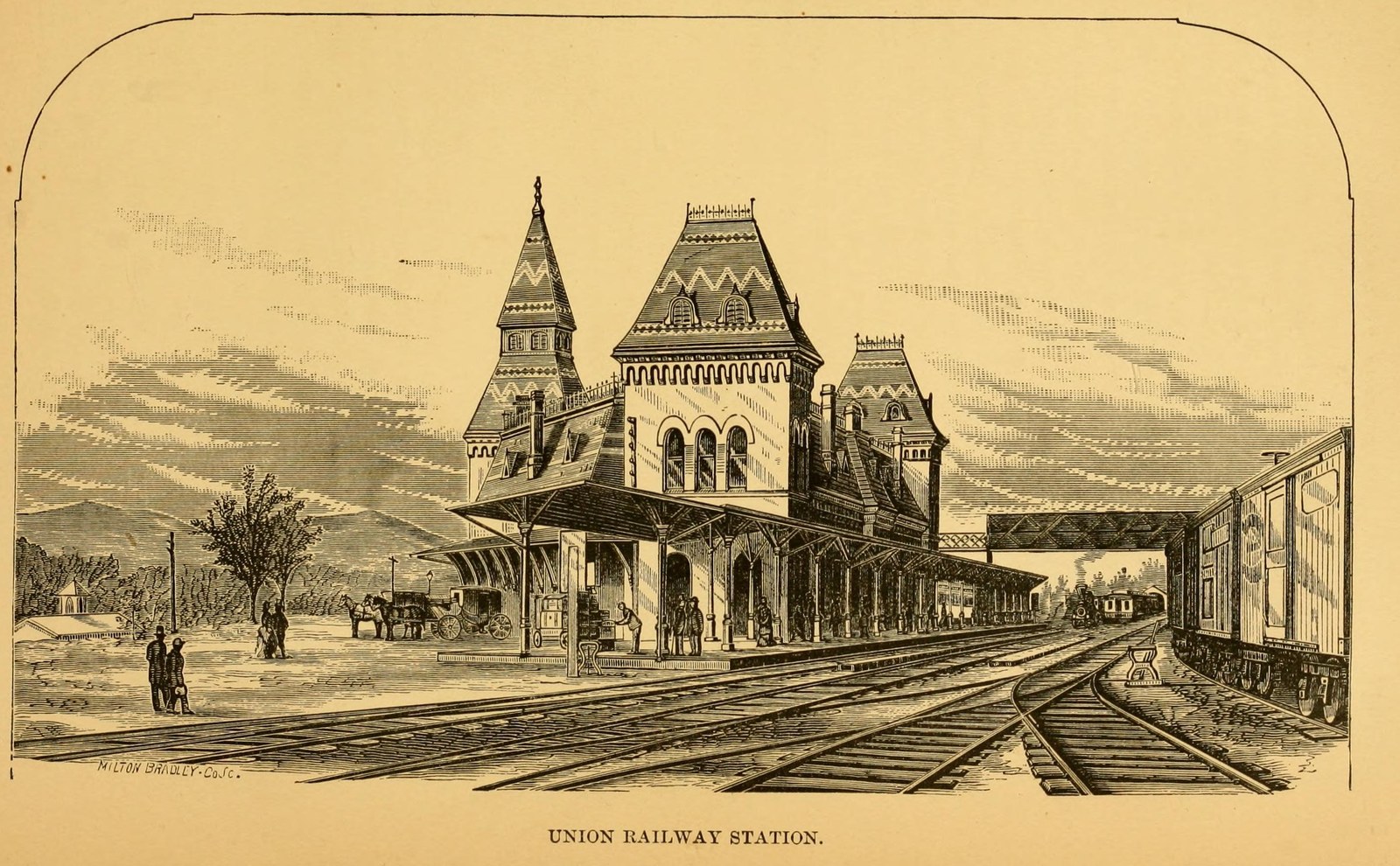
Smith’s second volume carries inserted engraved plates, and one of them — facing page 545, immediately after the passage above — is the station, signed MILTON BRADLEY CO. SC. It is at the head of this page. It is the best image of the 1866 building this site has found anywhere, it is out of copyright, and it has been sitting in a digitised book the whole time.
What it shows: a three-cornered building with a tower at each corner, the center one tallest, roofed in patterned slate with iron cresting along the ridge and a triple arched window under it. A canopy on turned iron columns runs the length of the track frontage, with baggage barrows and two dozen figures under it. An omnibus and pair stand at the left. A lattice footbridge crosses the tracks behind the building, and beyond it a train is coming in. Hills close the view, which is the one detail no photograph of the site would give you now.
Two figures circulate for this building that are worth marking. The 7,456 square feet, and the description of the plan as an obtuse triangle, are not in Smith — the full text has been searched and neither is there. Both trace to a Berkshire Eagle piece of December 1956 by way of Wikipedia, and that newspaper is not online. They may well be right. They are not Smith, and they are cited as Smith all over the internet.
And the architect is nowhere. Not in the statute, not in Smith — who names architects elsewhere in the same volume, Louis Weisbein for the county buildings and P. C. Keely for a church — not in Boltwood’s continuation of 1916, not in any architectural database. A building described in its own town’s history as one of the most beautiful in the country, and nobody wrote down who drew it. That is a question for the Berkshire County Eagle of 1866 and the Berkshire Athenaeum’s local history room, not for the web.
III. What the atlas draws
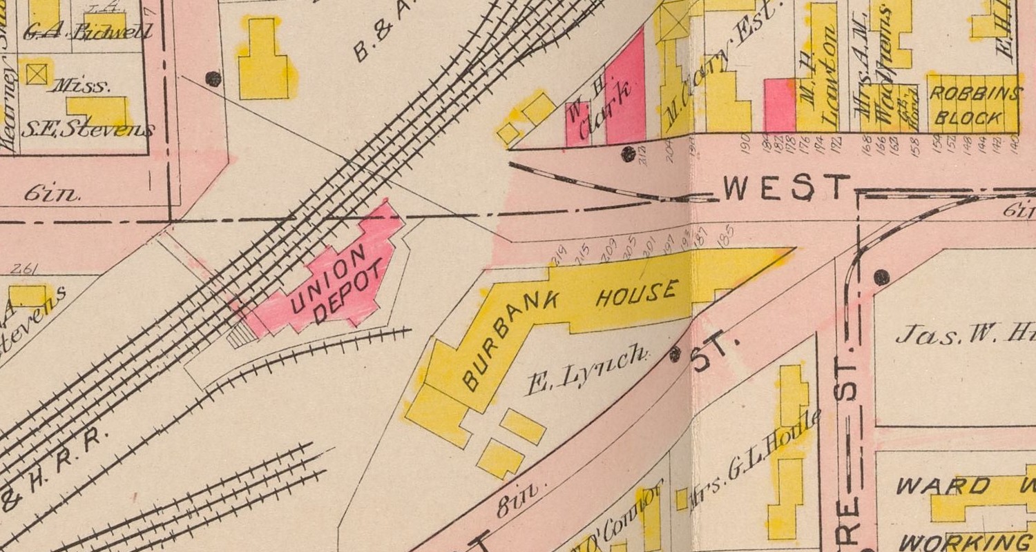
Compare the footprint with the engraving. The atlas draftsman, working from the assessors’ ground and not from a view, drew a wedge with its long side to the tracks and a projecting bay on the street side — which is the same building the engraver drew from the platform, and an independent confirmation of the three-cornered plan by somebody who was measuring rather than composing.
Look at West Street on that detail. It runs in from the east, and it stops. The dashed line continues where the street does not. That is chapter 126 of 1866, drawn.
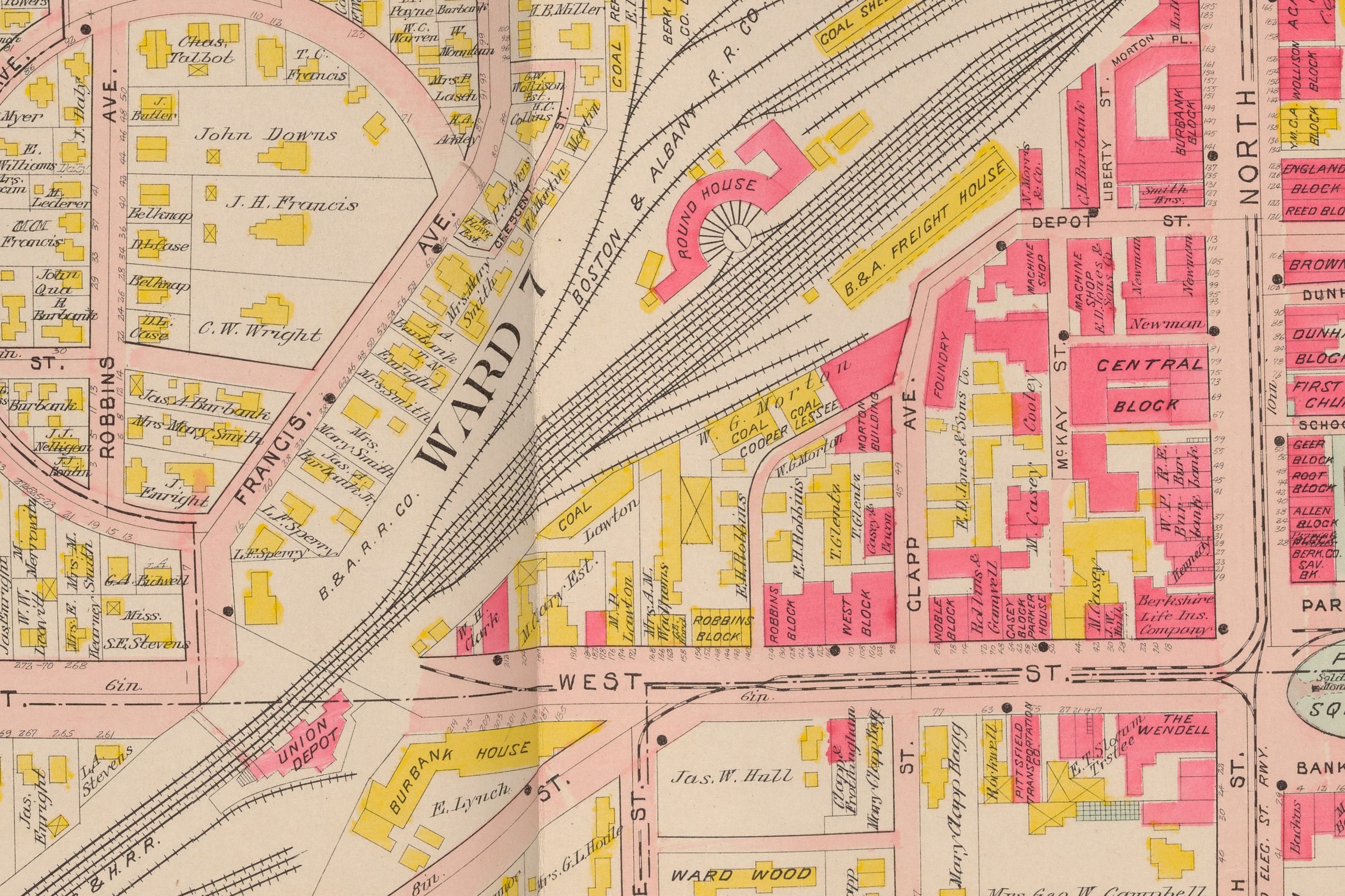
The yard is the argument for why any of this was here. Fifteen tracks, a roundhouse, a freight house, four coal dealers with their own sheds, a lumber company, a refrigerator house, a machine shop and a foundry within two blocks — and then, a hundred yards east, the hotels. The station was not a civic ornament that happened to sit near some tracks. It was the passenger end of a coal and freight operation that occupied the middle of the town.
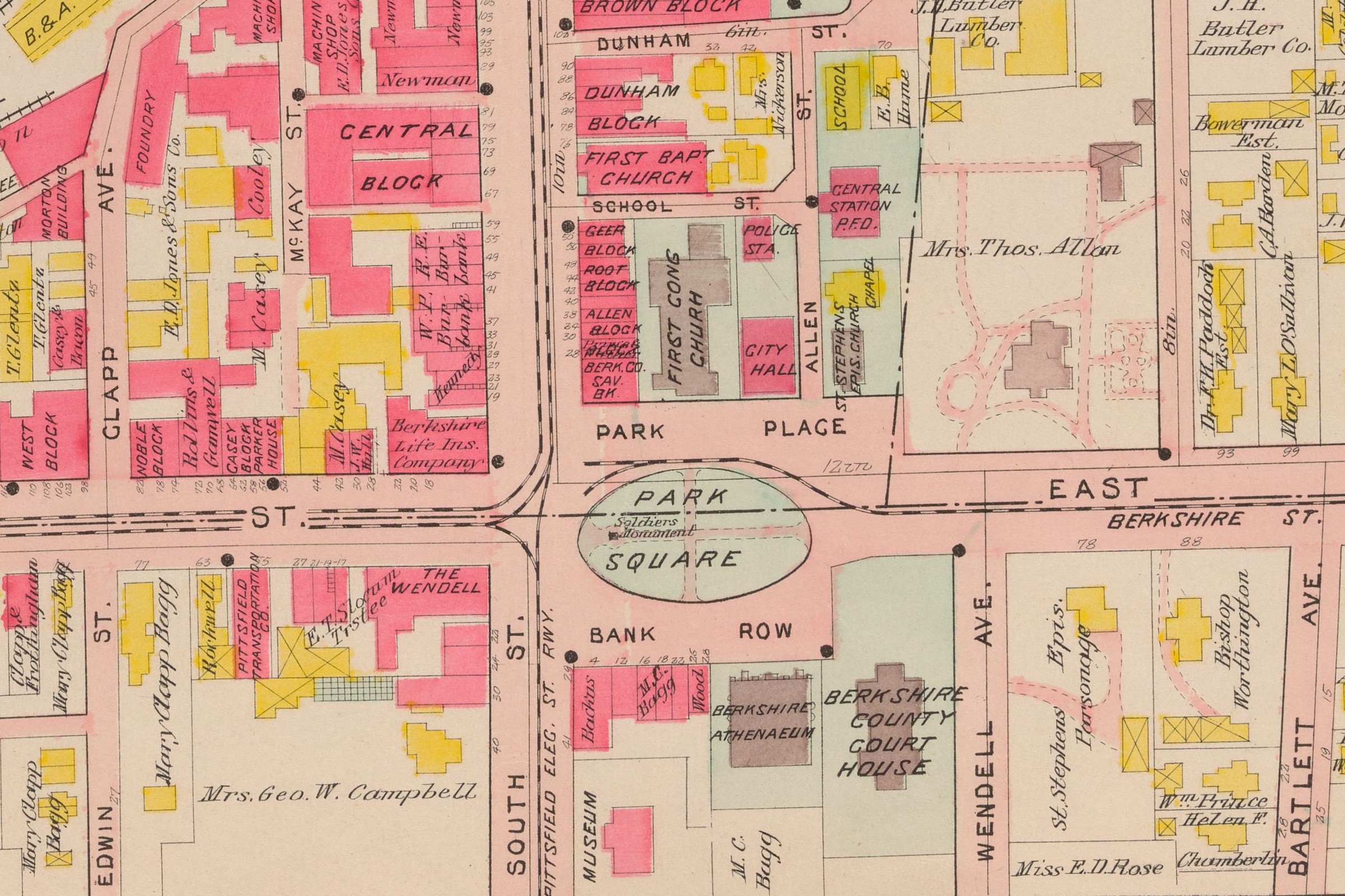
The walk from the depot to Park Square is four blocks of West Street, and the atlas letters almost every building on it: the Robbins Block, the West Block, the Noble Block, the Casey Block, the Parker House, the Berkshire Life Insurance Company, the Central Block. The Wendell is at the corner.
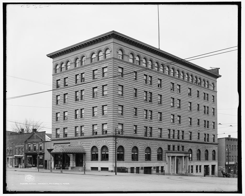
IV. 1914
Edward Boltwood, continuing Smith’s history down to 1916, gives the replacement two sentences and gets more into them than anyone since:
“The New York, New Haven, and Hartford Railroad Company, having acquired the former Burbank Hotel property, broke ground on that site in 1913 for a new station, and upon its completion razed the veteran structure nearby.”
That is the Burbank House on the atlas detail above, bought and built over. Boltwood dates the opening to 23 August 1914; the date in general circulation, and on Wikipedia, is 24 August. Boltwood was writing two years after the event in the town it happened in. Both dates stand here.
He also names the committee the mayor appointed to deal with the railroad — Zenas Crane, John A. Spoor and John C. Crosby — and calls the building it replaced “the triangular building which had served for forty years.” Forty-eight, by the statute; but triangular, from a man who had seen it.
The new station was Beaux Arts, and what it was like inside survives only in description. Amtrak’s own account of the site gives it “tall arched windows, green-veined marble walls, a high-domed terrazzo ceiling, skylight, chandeliers and polished woodwork,” a mosaic of the city seal set into the entrance floor, and a restaurant. Jim Shulman, writing in the Eagle, has the same room from a different direction: “a mosaic-tiled floor with the city seal, a polished terrazzo ceiling with picturesque skylights, and walls with large arched windows.” The dome is Amtrak’s word alone.
The cost is given as $300,000 by Amtrak and by Shulman. A figure of $400,000 all told, with $300,000 for the station itself, appears only in Wikipedia’s reading of that same December 1956 Eagle piece. The 17,953 square feet, and the red brick with white terra cotta trim, come from the same unavailable article.
This architect is missing too. Boltwood does not name him, writing two years after the opening; neither does Amtrak, nor the Eagle’s retrospectives, nor any architectural index. There is one good lead and it is a specific one: Historic New England holds the Boston & Albany Railroad Company’s photographic collection, and in it is a glass plate negative catalogued “Railroad station construction, photograph of architect’s plans, Pittsfield, Mass., 9681-B” — a photograph of the actual plan sheets, basement, first and second floors. Title blocks carry names. Nobody appears to have looked.
V. The footbridge
There is a footbridge over the tracks in the 1876 engraving, at the right of the plate, lattice-sided. The Eagle records a West Street footbridge of 1873 which by 1913 was judged unsafe and was replaced during the station work. The engraving is 1876. The page does not join those two facts for you; it puts them next to each other.
Its replacement is well documented: 150 feet by 10 feet, three flights of stairs and two landings, built by the Boston & Albany in 1913 and opened in December 1914, four months after the station. In January 1960 the railroad told the city it was abandoning the bridge, “as almost no one crossed it for the limited train service available then.” The city took it over and spent $6,700 on repairs.
VI. Taken down
In 1956 the New York Central offered the station to the city for a city hall. Amtrak and Wikipedia both describe the offer as a sale; Shulman calls it a gift. The city declined it either way — because the building was unsuited to the use, says one account; because decades of deferred maintenance had left it in very poor condition, says the other.
In 1965 the city council allowed the railroad to build a new passenger facility two miles east, out by the General Electric plants and away from the center of town. One city councillor objected. His name was Joseph Scelsi, and it is on the building Pittsfield eventually put back downtown.
By 1966 restoration was no longer economic. In 1967 the Pittsfield Housing Authority bought Zenas Crane Memorial Park from the city for $105,000 and bulldozed it for a supermarket. In 1968 the station came down. The supermarket on the site is now a Big Y, and it covers both the park and the station ground.
On 22 November 2004 the Joseph Scelsi Intermodal Transportation Center opened. Senator Edward Kennedy and Representative John Olver set the last two bricks into a column on the Columbus Avenue side — two bricks saved from the 1914 station. That is what is left of it, and it is two bricks.
VII. The number
The figure that circulates for the Pittsfield clearances is “more than 86 acres of land and 200 structures.” It is worth being exact about where it comes from, because it is usually attached to the wrong year.
It is a 1973 figure, not a 1968 one. It appears in the Berkshire Eagle of 24 January 2024: “Fifty years ago last fall, in 1973, urban renewal demolitions leveled more than 86 acres of land and 200 structures in and around downtown.” The same paper repeated it on 27 January 2025. In the 2024 piece the acreage is broken out by a speaker, Tessa Kelly: 25 acres in the Columbus neighborhood and 61 acres in the Jubilee project.
Three things follow from that, and all three are reasons to handle the number carefully.
- 25 and 61 make exactly 86, so “more than 86 acres” is loose phrasing rather than a separate measurement.
- The split is a figure quoted by a speaker at a public event in 2024, not a number read off a project record.
- The clearances were not one year’s work. The Eagle announced the first tract on 24 February 1962 — “59-Acre Tract Is Selected To Launch Pittsfield Urban Renewal Program: Pittsfield ‘Jubilee Project’ Before Council On Tuesday” — 59 acres then, 61 in the 2024 account. Demolitions were under way by 1967. The federal program was canceled in 1974. Eighty-six acres is a cumulative project area across more than a decade, and 1973 is where a fiftieth-anniversary clock was started.
As for how many buildings: no defensible count exists. “More than 200 structures” is one newsroom’s figure, published in 2024, with no underlying document cited, no method and no date range. The only dated documentary count found anywhere is a Berkshire Eagle headline of 16 August 1966, page 13: “60 Housing Units Taken To Date For Jubilee.” Sixty housing units, as of one day in one summer. Everything past that would have to come out of the Pittsfield Redevelopment Authority’s own project files or the federal ones, and nobody has put them online.
So: the station came down in 1968, in the middle of a clearance program that ran from 1962 to about 1974 and took most of the West Side. A number widely attached to 1968 belongs to 1973 and cannot be traced to a record. This site does not know how many buildings were destroyed in Pittsfield, and neither, on the evidence, does anybody writing about it.
One more thing, and it is the coincidence this story was written for. The 1866 act moved West Street around the end of the new depot and up to “the westerly declivity of Jubilee Hill, so called.” A hundred years later the project that cleared the ground the street ran through was called the Jubilee project. The hill kept its name through both.
VIII. The before-document
Plate 2 is worth opening for its own sake. Eight hundred and sixty-one entries: the depot, the roundhouse, the freight house, four coal yards, the Wendell and the Parker House and the Norwood and the New American, City Hall, the Academy of Music, the Berkshire Athenaeum, the Court House, Park Square with the Soldiers Monument, the Maplewood Hotel in its grounds at the top of the sheet, and street after street of small yellow houses on the west side with a family name lettered on every lot — John Downs, J. H. Francis, Jas. A. Burbank, C. W. Wright, Mary Smith, L. F. Sperry.
The Jubilee project ran, by the account of the case study written about it, from Park Square to the West Street bridge and east up Jubilee Hill; the Columbus plan took the ground around Columbus and Francis Avenues. Which of these particular lots went, and in which year, is not something this site can tell you. But the names lettered on them are the nearest thing there is to a list of who was there before.
The 1866 act: Acts and Resolves Passed by the General Court of Massachusetts in the Year 1866, chapter 126, approved 7 April 1866, quoted from the volume text on the Internet Archive, which records it as not in copyright. The 1866 depot, the closing of West Street, the “most convenient and beautiful” phrase and the footnote on the Western and the Boston and Albany: J. E. A. Smith, The History of Pittsfield (Berkshire County), Massachusetts, From the Year 1800 to the Year 1876 (Springfield: C. W. Bryan & Co., 1876), vol. 2, pp. 543–44 and the plate facing p. 545, scanned by the Internet Archive from the University of Massachusetts Amherst copy. Note that the Internet Archive’s own metadata for that scan gives a different publisher and date from the title page; the title page is followed here. The 1914 station, the Burbank Hotel property, the mayor’s committee and “the triangular building which had served for forty years”: Edward Boltwood, The History of Pittsfield, Massachusetts, from the Year 1876 to the Year 1916 (1916), pp. 106–07. Interior, cost, the 1956 offer, the 1965 relocation, the 1966 assessment, the 1968 demolition and the 2004 bricks: Amtrak, Great American Stations: Pittsfield, MA (PIT). The footbridge, the 1873 predecessor, the January 1960 abandonment and the 1967 purchase of Zenas Crane Memorial Park: Jim Shulman in The Berkshire Eagle, 20 April 2024. Urban renewal acreage and structures: The Berkshire Eagle, 24 January 2024, repeated 27 January 2025. The 1962 and 1966 Eagle headlines are cited as they appear in the NAACP Berkshire County case study Pittsfield Westside Neighborhood: Redlining in the Mill Towns of New England; the pages themselves are behind the newspaper’s paywall and have not been seen here. Square footages for both buildings, the terra cotta trim and the $400,000 total derive from a Berkshire Eagle article of December 1956 which is not available online and has not been read; they are given here as attributed figures, not as established ones. Plates: Atlas of Berkshire County, Massachusetts, Barnes & Farnham, 1904. Boston Public Library copy, via Digital Commonwealth. No known copyright restrictions. Reproduced in full here. Hotel Wendell: Detroit Publishing Company, between 1900 and 1915. Library of Congress Prints and Photographs Division. No known restrictions on publication. Neither architect has been found; if you know either name, it belongs on this page.