This story is about the speed of documents. A court can change the law in an afternoon. A word can sit on a piece of ground, in the deeds and then on the state’s own map, for a generation and more. A printed form can go on asking a state a question the state answered in 1783 until a war makes it stop. All three happened here, to the same town, and the gap between them is the subject.
I. 8 July 1783
There is a single sheet of paper at the Connecticut Museum of Culture and History — the Connecticut Historical Society until 2023 — with a red wax seal still on it, signed at Head Quarters in the State of New York and countersigned by an aide de camp. It reads, in part:
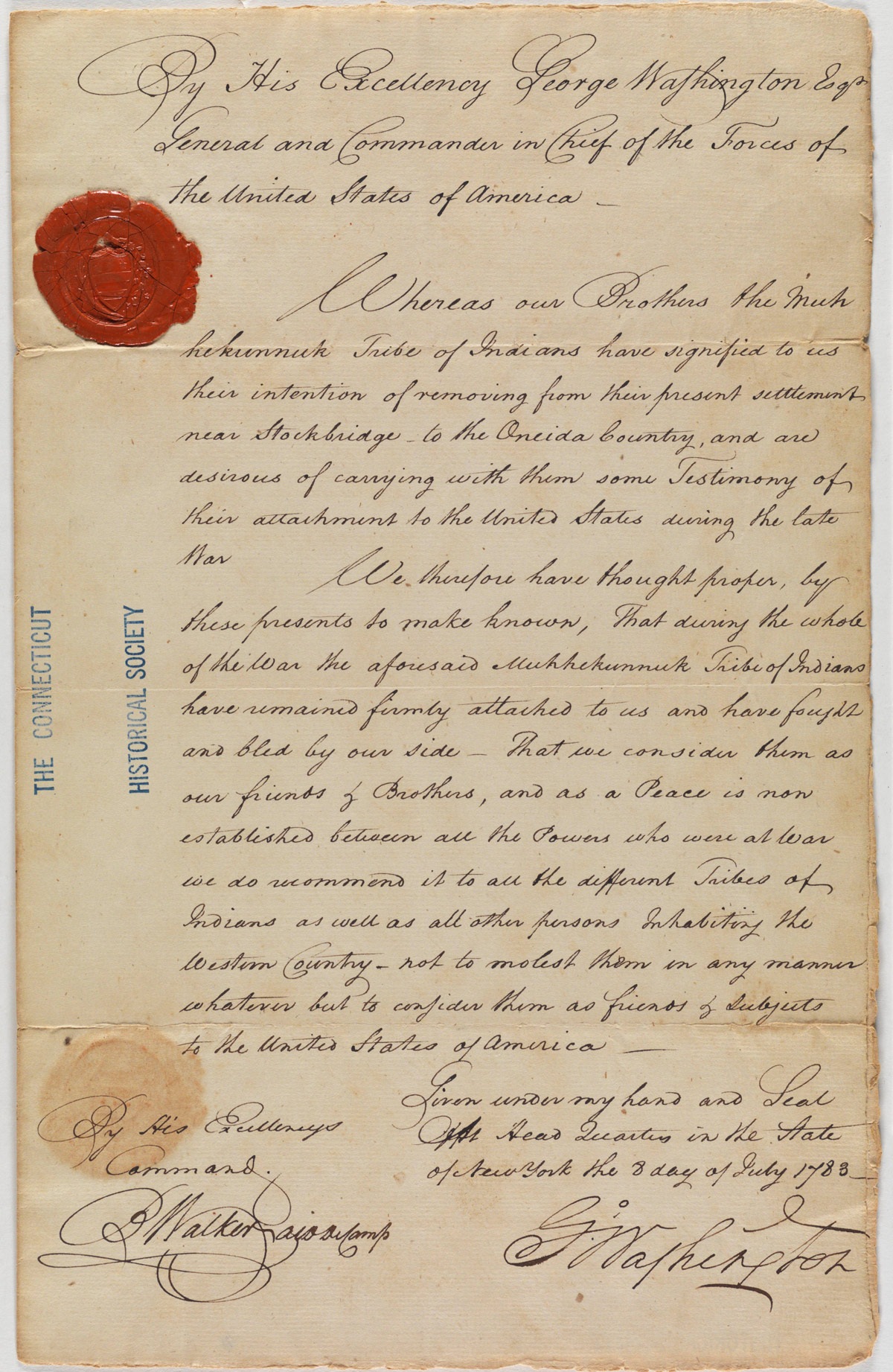
By His Excellency George Washington Esqr General and Commander in Chief of the Forces of the United States of America —
Whereas our Brothers the Muhhekunnuk Tribe of Indians have signified to us their intention of removing from their present settlement near Stockbridge to the Oneida Country, and are desirous of carrying with them some Testimony of their attachment to the United States during the late War
We therefore have thought proper, by these presents to make known, That during the whole of the War the aforesaid Muhhekunnuk Tribe of Indians have remained firmly attached to us and have fought and bled by our side — That we consider them as our friends & Brothers, and as a Peace is now established between all the Powers who were at War we do recommend it to all the different Tribes of Indians as well as all other persons Inhabiting the Western Country — not to molest them in any manner whatever but to consider them as friends & Subjects to the United States of America —
Read what that document is, and then read what it is not.
It is a testimonial, handsomely written, personally signed and sealed by the most consequential man in America. It states that these people fought and bled for the country. It is also, as an instrument, worth nothing. It does not grant land, confirm a title, or impose a duty on anybody. It recommends. And the people it recommends are described in the opening clause as already leaving — have signified to us their intention of removing — so the document records, in its own first sentence, that the honoring and the losing are happening on the same day.
One more thing about this sheet, and it is not a small one. It was made for them. The letter says so in its own second clause — they were desirous of carrying with them some Testimony. It was written out and sealed for them to take with them. It was theirs.
It is now in Hartford.
Nothing consulted for this story records how it got there; the accession file at the museum presumably does. What can be set beside that gap is the account the Stockbridge-Munsee Community, Band of Mohican Indians gives of the years after the removal — reported to the author directly — that in periods of severe poverty in Wisconsin, collectors came out and bought artifacts from Mohican families for very little. Whether that is the route this particular sheet took is not known here and is not claimed. But a document made for a people to carry with them has ended up in a collection in Hartford, and how that happened is a fair question with an answer in somebody’s ledger.
II. Five years earlier
On 31 August 1778 a company of Stockbridge men, between forty and sixty strong, was operating near Van Cortlandt’s Ridge, north of Manhattan, and marched into a trap laid by more than five hundred British troops, the Queen’s Rangers and the Legion cavalry among them. At least fourteen Mohicans were killed. The National Park Service puts the dead, Mohican and not, as high as forty.
That is what fought and bled by our side means in the letter. Washington was not being decorative. The letter says during the whole of the War, and Van Cortlandt’s Ridge was five years before he signed it.
Fourteen does not read as a large loss by modern arithmetic, so set it against the people it came out of. In the early 1760s the Mohicans at Stockbridge numbered about five hundred, men, women and children together. Against a people that size, fourteen men in one afternoon is one person in every thirty-six. The first federal census, twelve years after the battle, cannot measure it for you. It counted Stockbridge at 1,336 people, and the column headed all other free Persons came to 64.
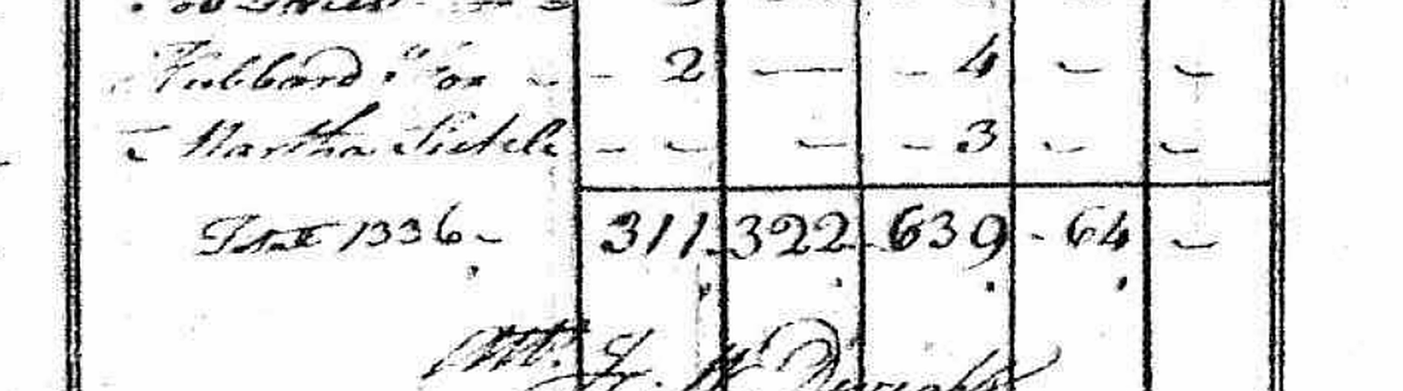
Sixty-four is not the Mohicans. The census did not count Indians who were not taxed, and by 1790 the main body had been gone five years. The 64 are chiefly the town’s free Black residents, and this story comes back to them in 1830.
One qualification, and it matters. The company is called the Stockbridge company and the Stockbridge-Munsee company in different sources, and it was not drawn solely from Mohican households resident in this town. The fourteen are Mohicans; the higher counts of the dead take in men of other nations.
The rest of the sequence is on paper. The General Court granted Stockbridge to them in 1737, unto the said Housatannuck Tribe of Indians and to their heirs and assigns TO their use and behoof forever. In 1765 it gave them leave to sell their outlands, on a petition that said such sales were needed when their needs require To pay the debts. In 1763 the Mohicans held about 23,000 acres, three-quarters of the land in the region; by 1775 they held 1,200. The list of the town’s Indian officers ends in 1779. The main body removed to New Stockbridge, in the Oneida country, in 1785, two years after the letter. In 1809 the Nation, writing from New Stockbridge, relinquished its burying ground here. From New York it was moved again: to the Fox River in Wisconsin after a treaty of 1822, to the shore of Lake Winnebago in 1834, and to Shawano County under the Treaty of 1856.
“Forever” turned out to be twenty-eight years, when the General Court opened the land to sale for debt; forty-two, at the last Indian name on the town’s list of officers; forty-eight, at the removal; or seventy-two, when the Nation gave up its burying ground to Dr. Oliver Partridge so that he would fence it. However you measure it, a promise made in 1737 was broken inside a lifetime.
The twenty-four years between the removal and the relinquishment were not empty. Families stayed behind — the widow of Captain Nimham and her daughter Lucretia, Captain Yokun, Catherine the widow of King Solomon, Widow Elizabeth — and Abraham Konkapot and his wife Hannah were the last to go, in a year the Bidwell House Museum’s account does not give. Nor did leaving settle it: for more than thirty years after the removal they came back on pilgrimage to the graves. The end of the Mohican town was not a date. It was a slow going, and a long returning.
III. The same year, in a courtroom
1783 is also the year the law of slavery ended in Massachusetts, and it ended the way the Mohican removal did not — quickly, and with force.
Two years earlier, on 21 August 1781, a jury at Great Barrington heard Brom and Bett v. Ashley, argued on the new state constitution’s promise that all men are born free and equal, and the next day found that the two were not and had never been Ashley’s lawful servants. Bett walked out free, with damages. She had asked a Sheffield lawyer named Theodore Sedgwick to bring the case. In April 1783, in the Quock Walker prosecution, Chief Justice Cushing charged a jury that there could be no such thing as perpetual servitude of a rational creature.
No statute was ever passed. Two juries and a judge did it, and it took about twenty months.
Elizabeth Freeman died in 1829 and is buried in the Stockbridge Cemetery inside the Sedgwick family circle. Her stone says she was born a slave and remained one for nearly thirty years, that she could neither read nor write, and that in her own sphere she had no superior or equal. Agrippa Hull, who had served as orderly to Colonel John Paterson and to Kosciuszko through the Revolution and was afterwards Theodore Sedgwick’s servant, died here in 1848 at eighty-nine.
IV. 1830: what the Commonwealth put on the map
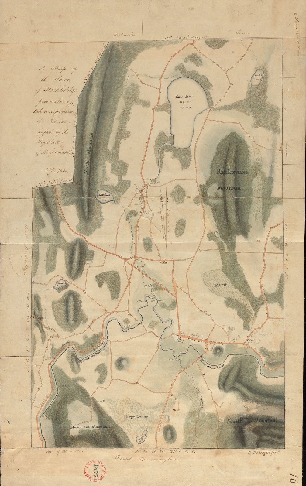
Forty-seven years after Cushing’s charge, the Legislature ordered every town in Massachusetts to survey itself and send the plan to the Secretary of the Commonwealth. The Stockbridge sheet is signed R P Morgan fecit, and it carries the authority of its own title block: from a Survey, taken in pursuance of a Resolve, passed by the Legislature of Massachusetts.
In the south of the town, between Monument Mountain and the Great Barrington line, the surveyor lettered Negro Swamp across a tract of low ground. On the water beside it he lettered Negro P., with its acreage under the name.
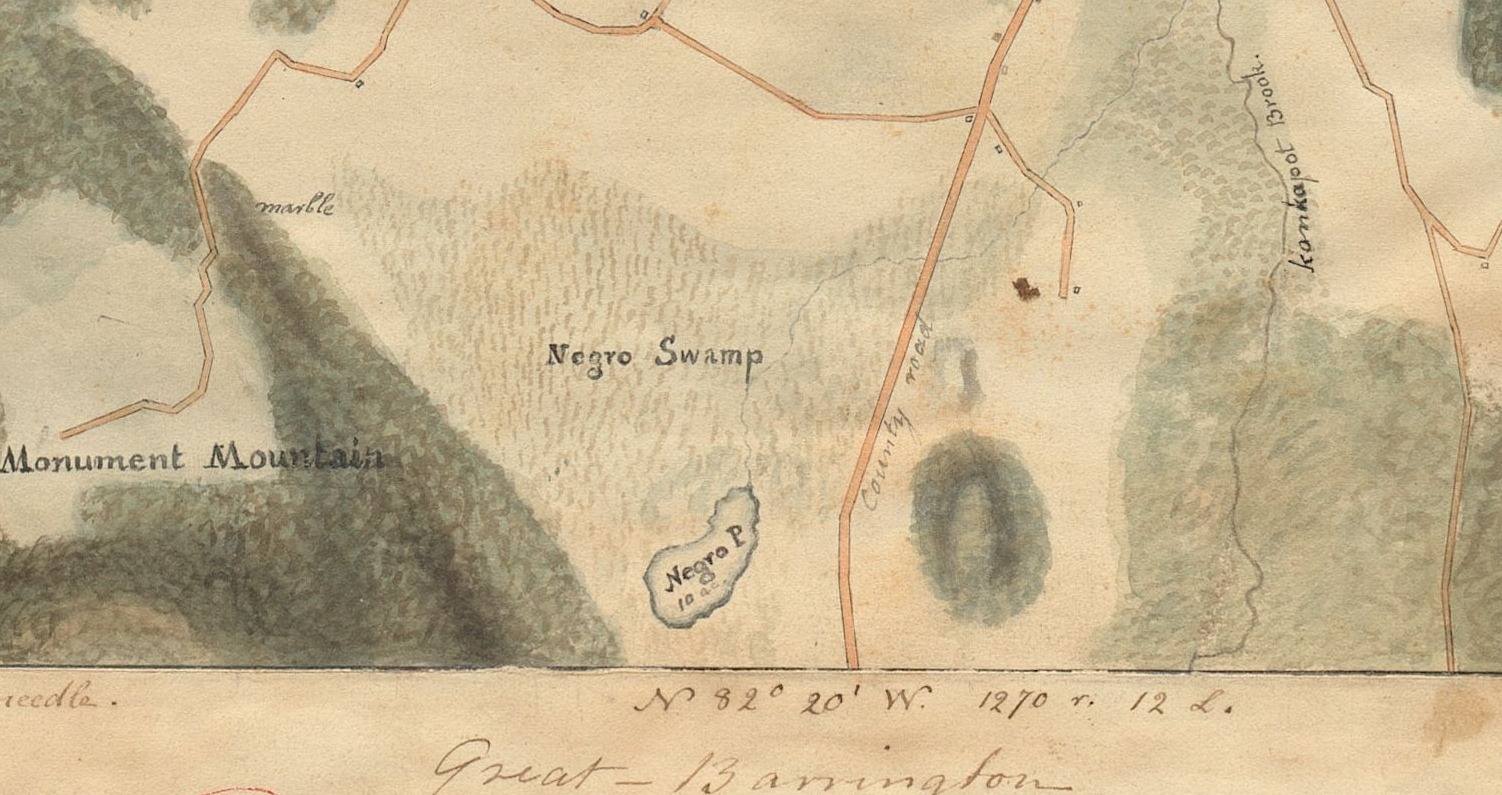
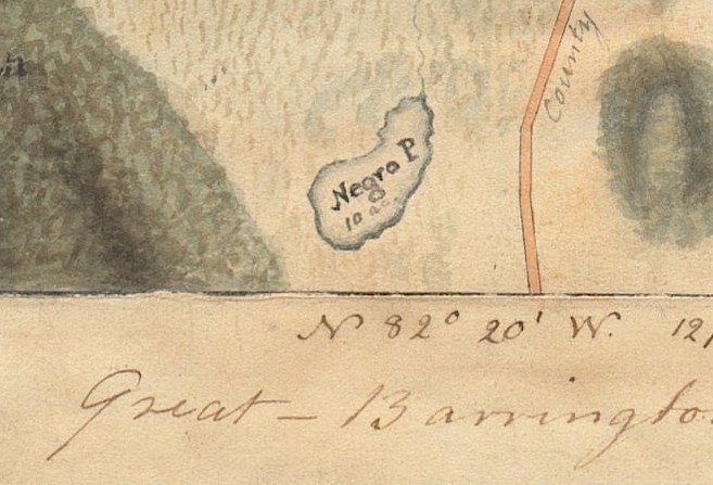
Be exact about what that is, because the first thing a modern reader sees is the wrong thing.
It is not a nickname on somebody’s private plan. The Legislature ordered the survey, the town’s surveyor did the lettering, and the Commonwealth filed the sheet. It is an official name, made under state law and kept in the state’s own archive.
V. The word, before anything else
Most readers in 2026 will take Negro on an 1830 map as a slur. It was not one, and the history is worth setting out plainly, because getting it wrong in either direction wrecks what the document actually shows.
In 1830 it was the ordinary descriptive word. It appears in statutes, in deeds, in the newspapers, and in abolitionist writing. It was also one of the words Black Americans used for themselves: Negro, colored and African were the three respectable options, and they spent the 1830s arguing among themselves about which to prefer. A century later Negro was a word of standing — the United Negro College Fund, Negro History Week, and W. E. B. Du Bois’s long campaign to force American printers to capitalize it as a mark of respect. The slur of the period was a different, corrupted word, and nobody confused the two. The federal census of this same year used free colored persons on its schedules.
Then the ground moved under it. In 1963 the United States Board on Geographic Names replaced the slur with Negro in hundreds of federal place names — the word was the remedy. In 2021 the Texas legislature passed a resolution calling for Negro to be struck from state place names as racially offensive. Neutral term, then term of respect, then the official correction, then the thing being corrected: a hundred and ninety years, and the ink never moved. The language moved underneath it. That is the same mechanism as the slaves column on the census form, running the other way, and it is why this page says what the word meant in 1830 before saying anything else.
VI. What the map is actually recording
None of which lets the document off. It makes it more exact.
A slur is somebody losing their temper. This is nobody losing their temper. This is a surveyor laying out a town for the Legislature and writing down a name the town already used — the way he wrote Monument Mountain and Rattlesnake Mountain — because it was useful. Because you could find the place that way.
The name was older than the map. When Timothy Edwards bought that ground from the Stockbridge Indians, the English called it Muddy Brook Swamp. In 1755 Joab Benney, entered in his deed as a Negroman a Freeman, bought fifty acres from John Skushawmh, a Mohican, in the Southerly part of said Township & on the East Side of the Road leading from Stockbridge to Sheffield, bounded on the east by Konkapot’s Brook. Morgan’s sheet draws the county road and Konkapot Brook running south side by side past the swamp, with wet ground between them. On 1 December 1807 Ephraim Taylor sold Elizabeth Freeman twelve and a half acres, part of Taylor’s Negro pond lot there so called, for forty-nine dollars. She had bought five acres from Thomas Peters four years before.
So the name is not a record of where Black families had been put. It is a record of where they had bought land, and of the town calling the place after them. Twenty-six years after she walked out of the Great Barrington courtroom, Elizabeth Freeman was buying land there in her own name.
That is what the 1830 sheet is evidence of. Not an insult. A settlement pattern, drawn in ink, filed in the archives of the Commonwealth.
VII. Agrippa Hull
The name this town remembers from that community is Agrippa Hull — Grippy — born 1759, orderly to Colonel John Paterson and then to Kosciuszko through the whole of the Revolution, afterwards Theodore Sedgwick’s servant, and a landowner in this town in his own right. He died here in 1848, aged eighty-nine. Local knowledge in Stockbridge puts his house at the corner of what is now Goodrich Street and South Street — the northern edge of the ground the survey lettered.
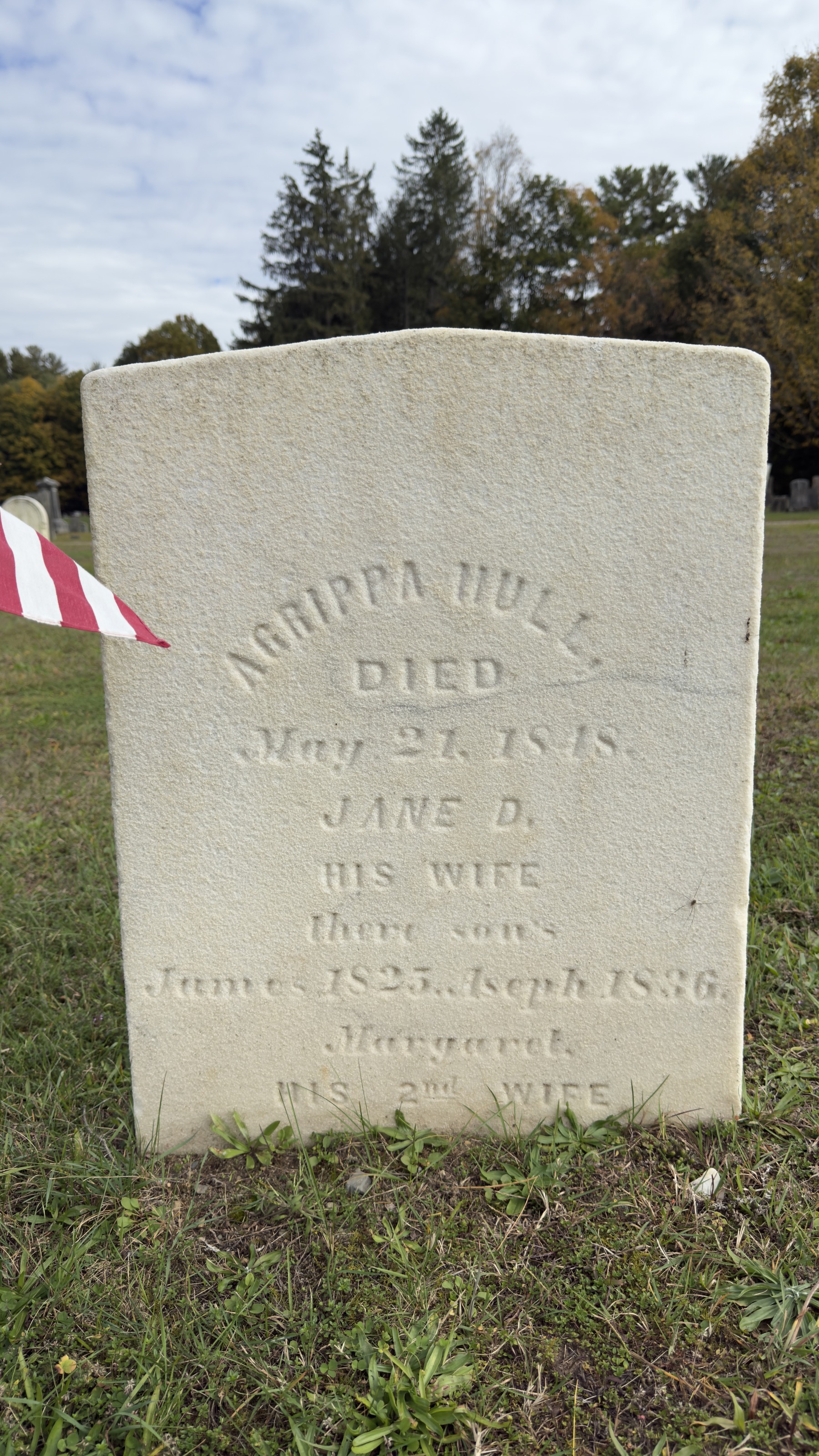
The stone gives the date as May 21. 1848., and lists Jane D., his wife, two sons, and Margaret, his second wife. The carver cut there sons for their sons, and it is left here as cut.
That is a location, not a deed, and this page claims no more. Nothing consulted here shows what Hull held or where its bounds ran, and the 1830 sheet is a topographical survey rather than a property atlas — it draws roads and water and mountains and almost no owners. The registry would answer it.
But hold the two facts together. A man who gave the Revolution six years, who was known by name to everybody in this town and buried in it, lived at the top of a piece of ground the state’s map named for the race of the people who had bought land on it. Both things are true at once, and that is the period exactly.
VIII. And what it kept printing on the forms
The same year, the federal census came through. It had been coming through since 1790, and the schedule it carried never stopped asking.
The first federal census, in 1790, had six columns, and the sixth was headed Slaves. Massachusetts and the District of Maine returned zero. On the Stockbridge sheet — page 590, 1,336 people — the enumerator drew a dash in that column on every line he wrote. Not left it blank. Marked it, household after household, in the only way the form gave him to write none.
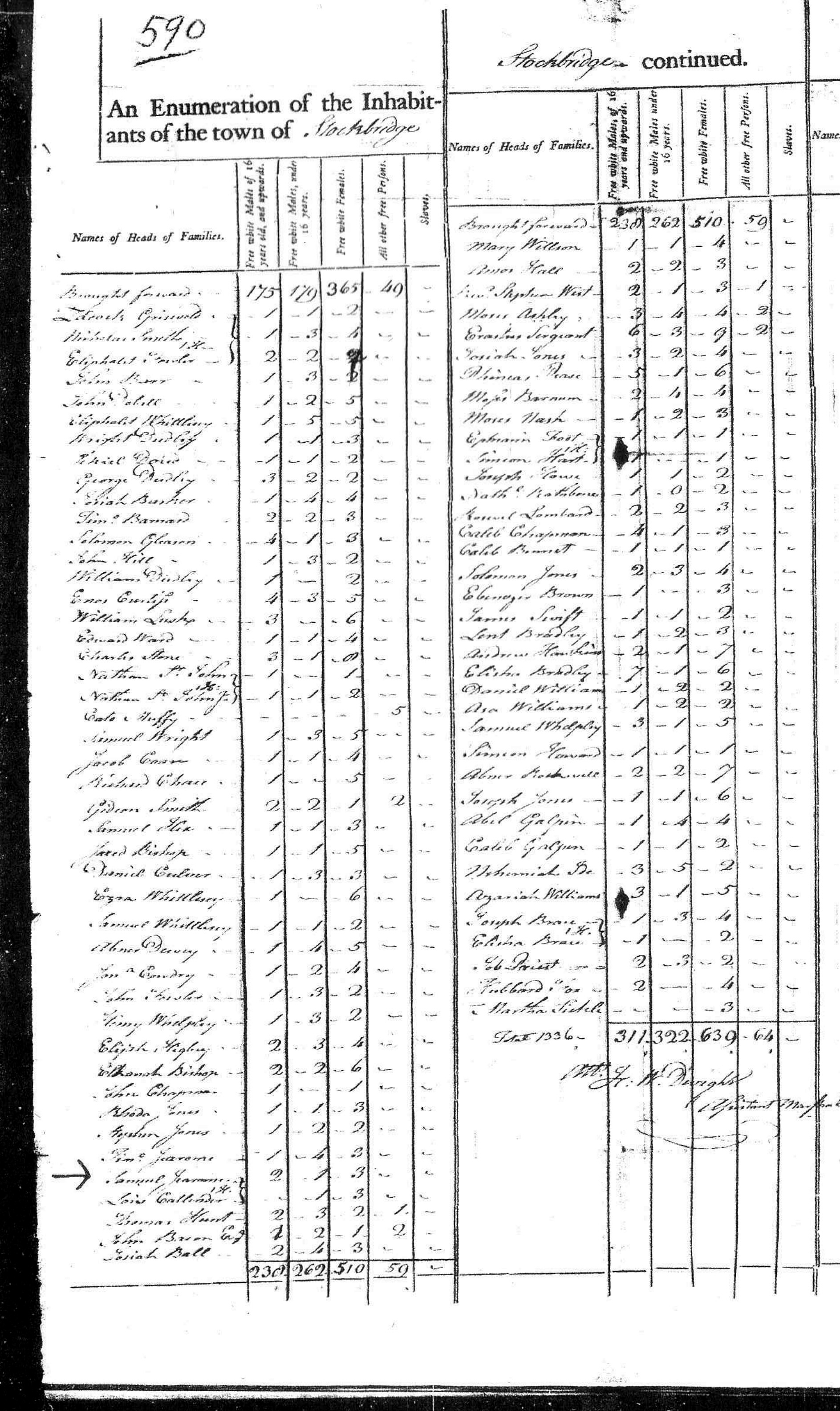
He had no choice about the column. Congress had fixed the six questions by the Act of 1 March 1790. It did not supply a form: the National Archives records that the government printed no blank schedules that year, and that Massachusetts was the only state where uniform printed forms were used, paid for by the marshal himself. So the ruled column on this sheet is a Massachusetts peculiarity — and the column was ruled whatever that state’s law happened to be.
And it kept being printed. Slave counts appear on the population schedule in 1800, 1810, 1820, 1830 and 1840. In 1850 and 1860 the form changed shape but not direction: free people were now listed by name with a column for Color, while enslaved people were moved onto a separate slave schedule that recorded no names at all — a number, an age, a color, and whether fugitive or manumitted.
The column came off in 1870, the first census after the Thirteenth Amendment, which is also the first census to list all Black Americans by name along with everyone else — free Black Americans had been named on the 1850 and 1860 schedules; the enslaved had not.
Eighty-seven years. The law changed in Massachusetts in 1783 and the federal form stopped asking Massachusetts about slaves in 1870 — eight more censuses, eight more sheets of dashes. The paperwork did not change when the law changed. It changed when a war changed it.
Worth noticing what else the form was doing in between. In 1790 and 1810 free Black residents are counted as all other free Persons, with no word for what they are, and in 1790 Indians who were not taxed are not counted at all — in this town, of all towns. By 1850 the free have their names printed and the enslaved still have none. The categories are never neutral and they are never stable. Each one is an argument about who gets to be a person with a name.
IX. 1858: what came off the map
Twenty-eight years after Morgan’s survey, Walling published his wall map of the county. Same ground, and at full resolution it is unambiguous.
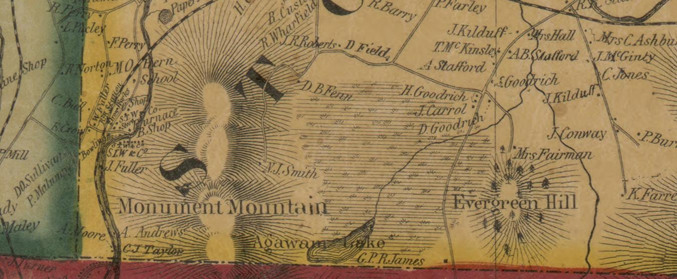
The marsh is still there and still drawn, with the hatching Walling uses for wet ground, and householders lettered across it — D. B. Fenn, H. Goodrich, J. Carrol, D. Goodrich, N. J. Smith. It carries no name at all. And the water is Agawam Lake.
So the change happened inside those twenty-eight years. By 1858 the swamp had lost its name and the pond had been given a new one. Eighteen years later Beers shows the same thing with the land now taken up by a residence.
X. 1876: and what replaced it
Beers, 1876. Same ground again.
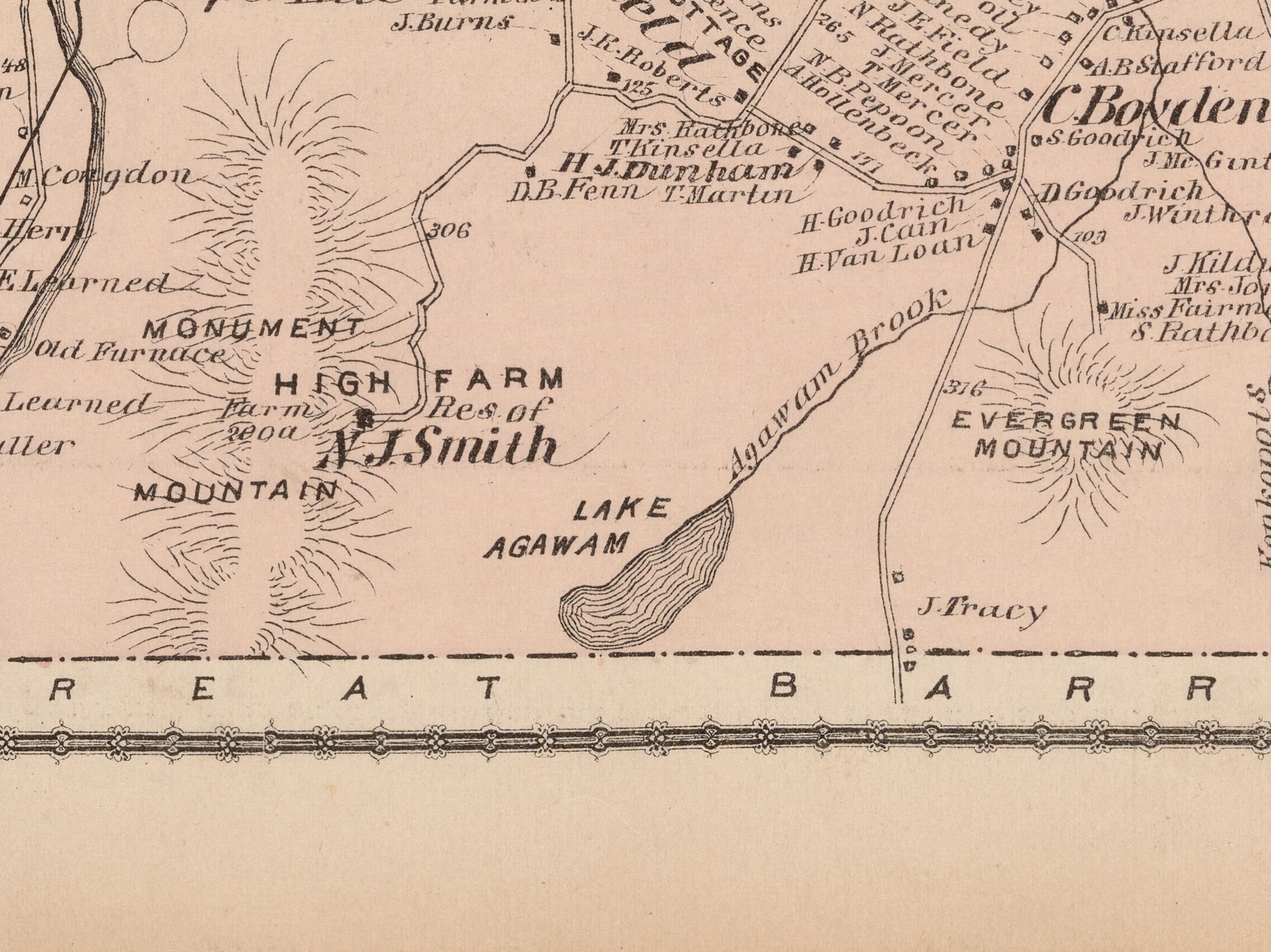
The swamp is not labeled at all. The land is HIGH FARM, Res. of N. J. Smith. And the water — the same body of water, identified on the ground — is LAKE AGAWAM.
The name came off the maps between 1830 and 1858, which is worth recording as a good thing. But look at what replaced it. Agawam is an Algonquian word. The pond lost the name of the town’s Black community and took on an Indian name — at a date when the main body of the Mohicans had been gone from Stockbridge for more than seventy years and had been moved three times since.
Picturesque Indian naming, applied after one people are gone, laid over the plain name of another people. Two renamings, one pond, and neither of them had anything to do with the people the names belonged to.
One name on the 1858 sheet is worth a reader’s attention, and no more than that. Lettered twice at the lake, on both sides of the town line, is G. P. R. James — George Payne Rainsford James, the English novelist, who had lived in Stockbridge earlier in the decade. That a romantic Indian lake-name appears on the map in the decade a professional romantic novelist had lived on its shore is a coincidence worth noticing and nothing more. No source consulted here connects him to the naming.
XI. Two kinds of paper
Lay the documents out and they sort themselves into two piles.
There is paper that honors. Washington’s testimonial, 1783. The 1809 deed by which the Mohicans relinquished the Indian Burying Ground to a friend for ten dollars and services rendered, so that he could fence it and “the bones of our Ancestors may there lie undisturbed.” Elizabeth Freeman’s gravestone, 1829, its epitaph written by Charles Sedgwick and the stone set inside his family’s own burial circle. The Indian Monument, raised in 1877 to “the friends of our fathers.”
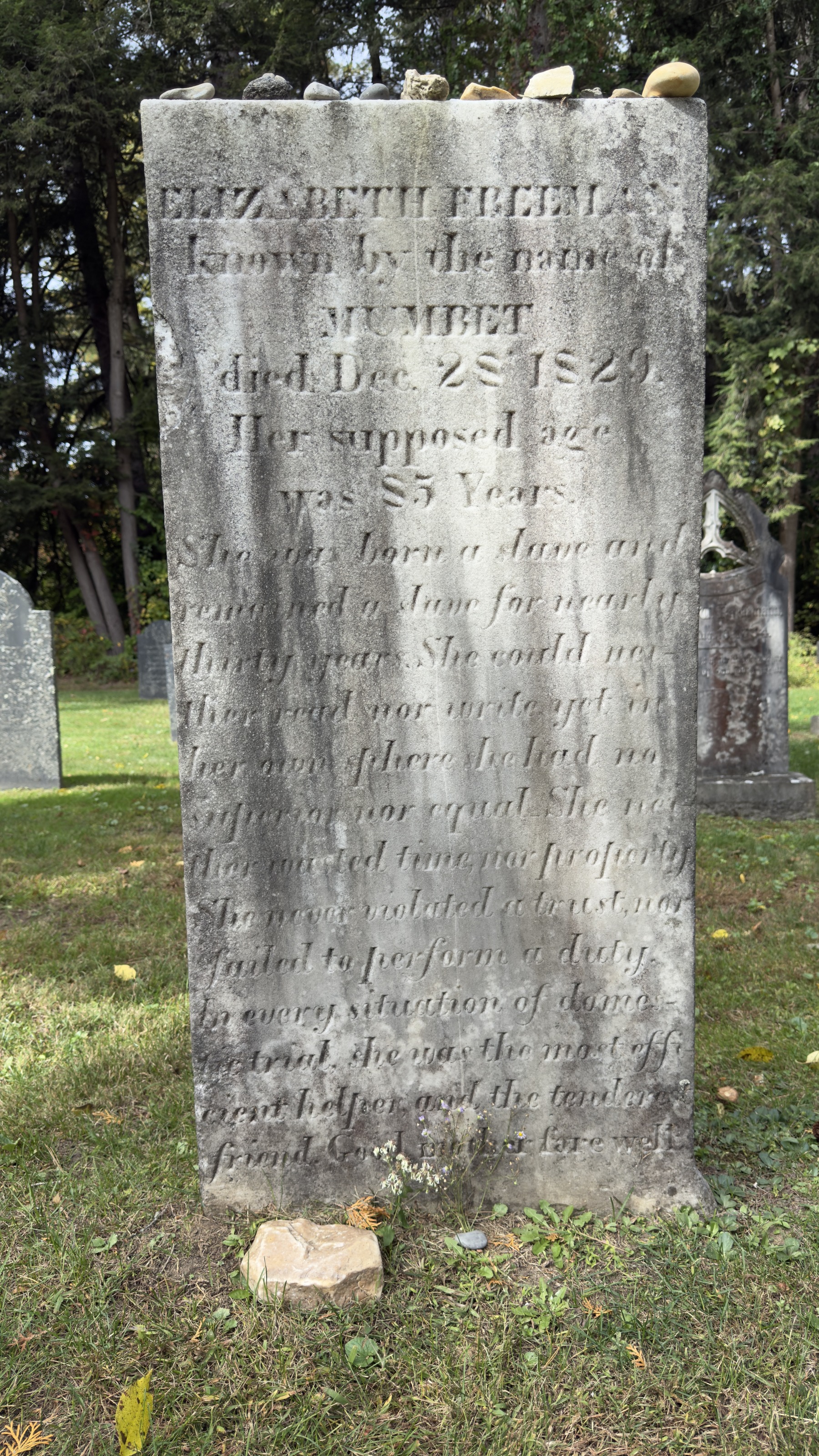
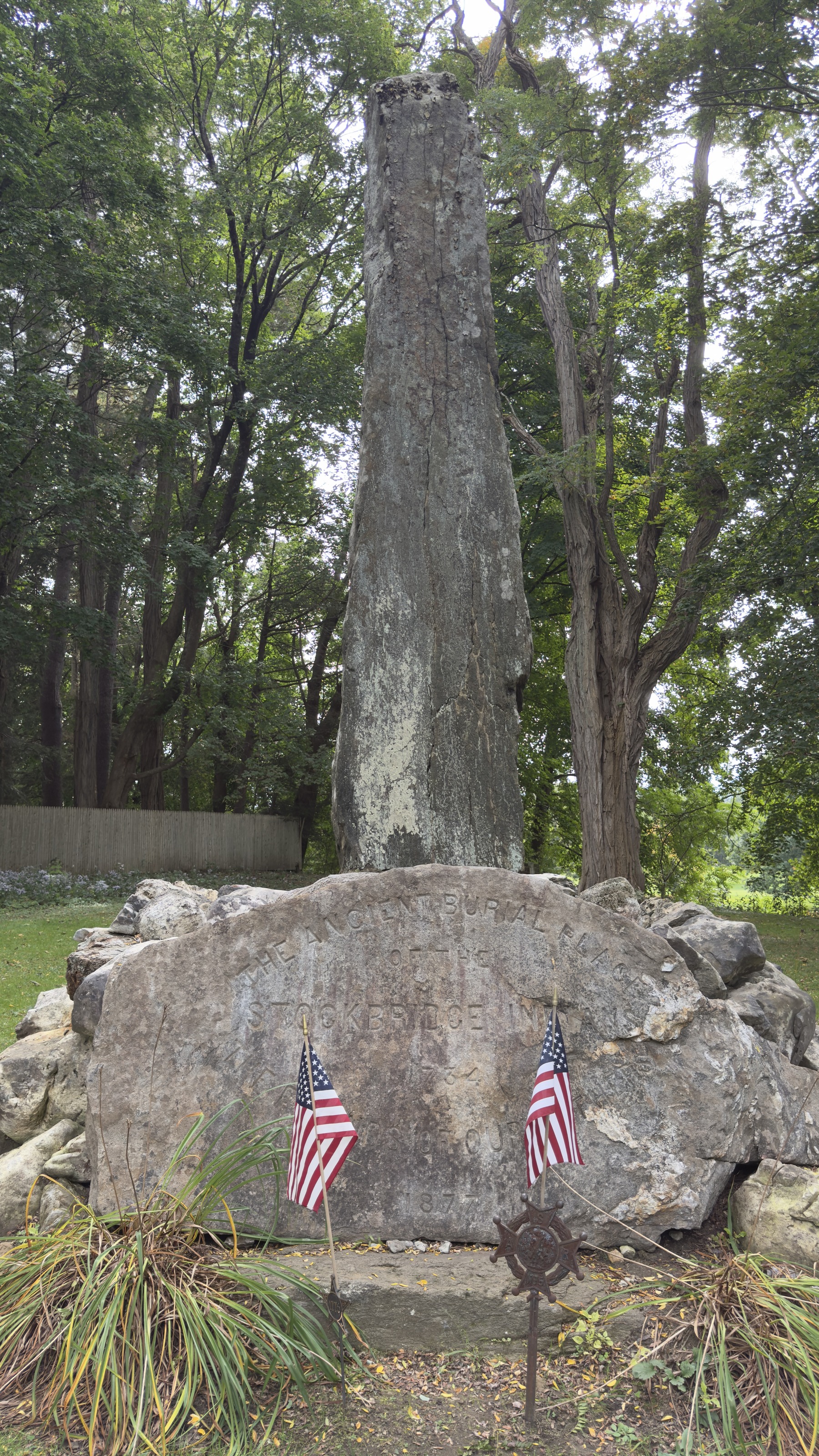
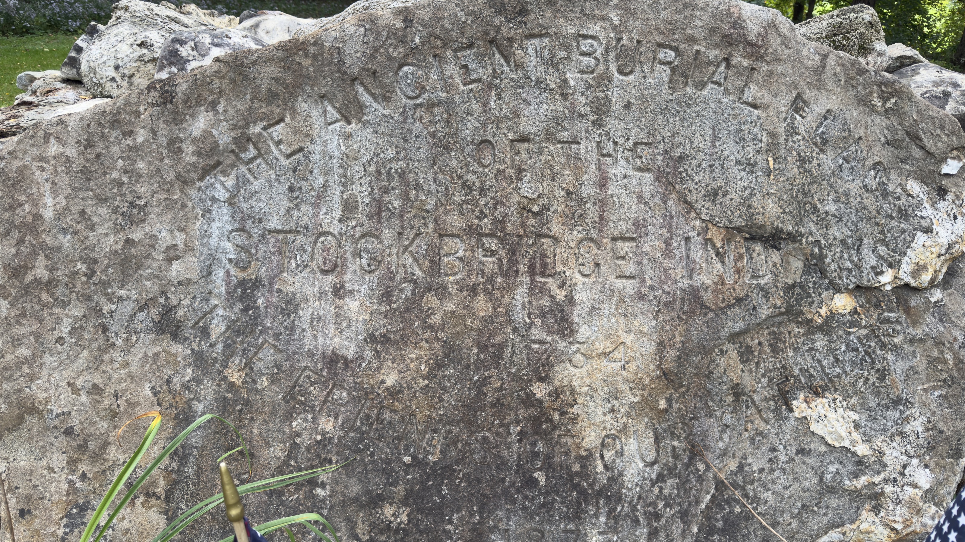
And there is paper that operates. The 1765 resolve that let Mohican land be sold for debt. The last Indian name on the town’s list of officers, 1779. The removal in 1785. The survey of 1830. The census column that ran to 1870. Deeds, schedules, resolves, plats.
The honoring paper is the better written of the two, and it is almost always later. Washington’s letter was written for a people already leaving, and its opening clause says so. The monument went up ninety-two years after the removal. The gravestone’s epitaph was written in the household she worked in afterwards, for wages. Every one of those documents is sincere, and not one of them moved a boundary, returned an acre, or struck a column off a form.
That is not an argument that the sentiment was false. It is an observation about which pile of paper the state keeps, and how long it keeps it. A court freed Elizabeth Freeman in two days. The ground she bought in 1807 was named for her people in her own deed, and still was on the state’s map in 1830. The census took eighty-seven years and a civil war.
And the one document in the honoring pile that was made to be carried — the one thing the Mohicans asked to take with them — is in Hartford.
The Washington testimonial of 8 July 1783 is in the collection of the Connecticut Museum of Culture and History, which was the Connecticut Historical Society until June 2023 and is still cited under the old name by Founders Online; it is reproduced here with that credit; the text is transcribed from the document, with its spellings as written. The manuscript is from 1783 and is in the public domain, and a faithful photographic reproduction of a flat public-domain document carries no separate copyright of its own. The Society is named because naming the holder is how a reader finds the original, which is this site’s practice for every collection it draws on. How the letter travelled from the people it was given to into a Connecticut collection is not recorded in anything consulted here; the museum’s accession record would settle it, and has not been asked for. The account of collectors buying artifacts cheaply from Mohican families during the Wisconsin years is the tribe’s own, reported to the author directly, and is given as that and not as a finding about this document. The Battle of Kingsbridge, 31 August 1778, and the dead as high as forty: National Park Service. The company’s strength of forty to sixty, at least fourteen Mohicans killed, a population of about five hundred in the early 1760s, and the land held in 1763 and in 1775: Justin F. Jackson, Berkshire Eagle, 27 December 2025. The fourteen are also in Charles Stuart’s report to Washington of 31 August 1778, as cited by Bryan Rindfleisch in the Journal of the American Revolution, after Patrick Frazier, The Mohicans of Stockbridge. The 1790 Stockbridge totals — 311, 322, 639 and 64, adding to the 1,336 written at the foot of the sheet — are read off page 590 itself; that the 1790 census did not count Indians who were not taxed is the Census Bureau’s account. The 1737 grant and the 1765 resolve are quoted as the Bidwell House Museum transcribes them. The list of the town’s Indian officers that ends in 1779 is the one Jones printed in 1854. The removal in 1785: Jones and the Wisconsin Historical Society; the Nation’s own history has it in the mid-1780s. The moves to the Fox River after the treaty of 1822, to Lake Winnebago in 1834, and to Shawano County under the Treaty of 1856 are from the Stockbridge-Munsee Community’s own history. The families who stayed on after 1785, the Konkapots as the last to leave, and the pilgrimages back are from the Bidwell House Museum, which gives no year for the Konkapots’ departure. The relinquishment of the Indian Burying Ground in 1809 — “in consideration of ten dollars in certain services rendered our tribe” and of the trust the tribe placed in him, so that he might fence it and prevent the soil from being removed, “that the bones of our Ancestors may there lie undisturbed” — is quoted from the deed as the Bidwell House Museum gives it; the town of Stockbridge posts the document itself, as a scan without searchable text. The grantee is Dr. Oliver Partridge, 1751–1848, the second physician to practice in Stockbridge, and not his father Colonel Oliver Partridge of Hatfield, 1712–1792. The instrument relinquishes the tribe’s right for the purpose of protecting the ground and is not described here as a sale, which is what its own consideration clause and its recital of trust support. Brom and Bett v. Ashley, heard at Great Barrington on 21 August 1781 and decided the next day, and the Quock Walker charge of April 1783: Massachusetts Historical Society and Mass Moments; the jury’s finding is quoted from the court record, and the constitutional argument was counsel’s. Elizabeth Freeman was held by Colonel John Ashley at Sheffield, not by the Sedgwicks; Theodore Sedgwick argued her case and she afterwards kept his household for about twenty years as a paid housekeeper, which is why her stone stands in his family’s circle. Her burial in the Sedgwick plot, the text of her stone and its epitaph by Charles Sedgwick, and Agrippa Hull’s dates, as recorded in the standard accounts. The usage history of the word: its ordinary descriptive use in the statutes, press and abolitionist writing of the period, and its use by Black Americans themselves, is a matter of general record; the 1830 federal schedules themselves read free colored persons. The United States Board on Geographic Names replaced the earlier slur with Negro in federal place names in 1963, on the Board’s own account of the decision; the Texas legislature’s resolution calling for Negro to be struck from state place names dates from 2021. Both are given here to show the direction the language travelled and not as findings about Stockbridge. Agrippa Hull’s service, his position in the Sedgwick household and his death here in 1848 are from the standard accounts; the location of his house at the Goodrich Street and South Street corner is local knowledge, reported to the author, and is not here taken from a deed — no instrument has been consulted, and the page claims a location only. The four photographs of Agrippa Hull’s stone, Elizabeth Freeman’s stone, the Indian Monument and its inscribed boulder were taken by the author in the Stockbridge Cemetery and at the west end of Main Street on 4 October 2026; the lettering is given as it reads on the stone. Theodore Sedgwick practiced at Great Barrington and Sheffield and did not move his practice to Stockbridge until 1785, so in August 1781 he was of Ashley’s own town: Massachusetts Historical Society, guide to the Sedgwick family papers. That the federal government supplied no printed schedules in 1790, and that Massachusetts alone used uniform printed forms at its marshal’s own expense, is the National Archives’ account of that census; printed federal forms begin in 1830. The 1850 and 1860 schedules named every free person, the enslaved appearing unnamed on separate slave schedules, per the Census Bureau’s own questionnaire documentation. Map, 1830: “A Map of the Town of Stockbridge,” R. P. Morgan, Massachusetts Archives, Maps and Plans; the title block and both place-names are quoted as lettered. The sheet is signed R P Morgan fecit; the Archives catalogue gives the surveyor’s name as not given. Every town was required to make such a plan by Resolves 1829, c. 50, and to send it to the Secretary of the Commonwealth: Massachusetts Archives. The deeds — Joab Benney’s of 25 September 1755, Hampden County Registry, Liber Y, folio 26a; Elizabeth Freeman’s from Thomas Peters, 1803, Book 41, page 277, and from Ephraim Taylor, 1 December 1807, Book 46, page 98 — and the note that the English called the ground Muddy Brook Swamp when Timothy Edwards bought it from the Stockbridge Indians, Middle Berkshire Registry, Book 19, page 415, are as the Bidwell House Museum prints them, from Rick Wilcox’s research. G. P. R. James’s years in Stockbridge: Wikipedia. Map, 1876: F. W. Beers, County Atlas of Berkshire, Massachusetts, plate 73. The identification of the 1830 pond with Lake Agawam is made locally, from the ground, and not from a georeferenced overlay; the two sheets are reproduced here so a reader can judge it. Census: the six columns of the 1790 schedule were fixed by the Act of 1 March 1790; the Stockbridge sheet is page 590, from a photocopy in the Procter family papers at Orleton Farm; the sequence of schedules 1790–1870 and the separate slave schedules of 1850 and 1860 from the National Archives. Map, 1858: Map of the County of Berkshire, Massachusetts, Henry Francis Walling, Library of Congress, g3763b la000307, public domain; the cut reproduced here is taken from the master scan at native resolution and the marsh on it carries no name. The window for the renaming is therefore 1830 to 1858, not 1830 to 1876.