Every plate of the Barnes & Farnham atlas carries the same nine-line key in its corner, and the fifth line is Green Houses. Not gardens, not grounds, not a conservatory attached to a house — the glasshouses themselves, drawn as buildings with their own color, and usually with the individual houses in a range ruled off one from another inside the outline. No other source maps them. The directories name gardeners; the photographs show lawns; only the atlas draws the glass.
I. What was found
40 ranges on fifteen plates, in 8 towns: Lenox 14, Pittsfield 9, Dalton 6, North Adams 6, Adams 2, Stockbridge 1, Lee 1, Williamstown 1. Counting the individual houses ruled off inside them comes to about 96, though that number is softer than the first one — at 500 feet to the inch the ruling is at the edge of what can be resolved, and several counts are marked uncertain in the notes.
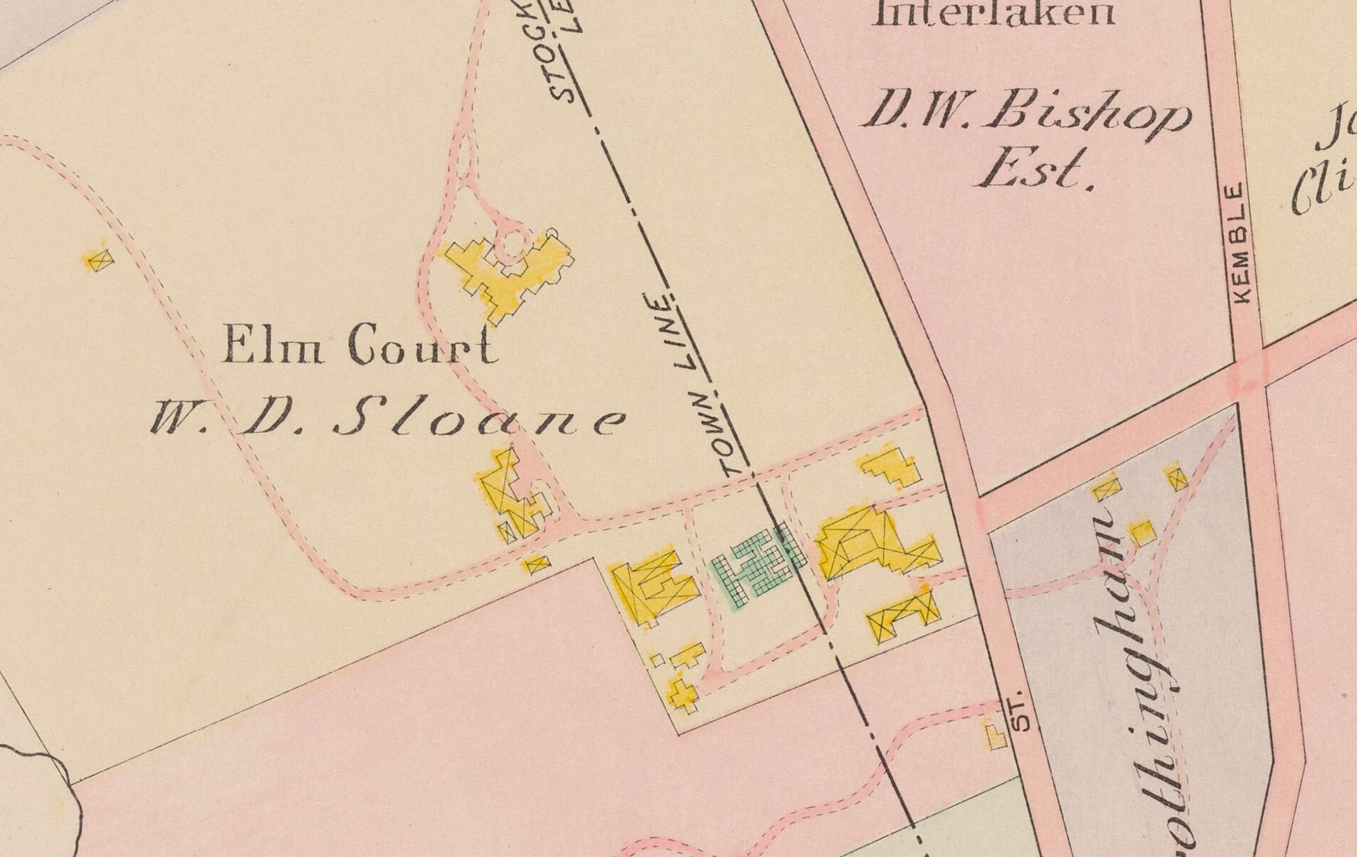
The largest single range in the county is Giraud Foster’s at Bellefontaine, about eight houses. Behind it come Elm Court and W. R. Allen’s in Pittsfield, both around seven.
The surprise is where the glass actually is. Lenox has the most, which is what anyone would guess. But Pittsfield has nine ranges and at least three of them are trade, not display: R. C. Engleman & Sons and T. L. Lowden & Sons are commercial florists’ ranges, and Mrs. G. A. Parker’s four houses stand on a parcel with a barn and no dwelling drawn on it at all. North Adams and Adams have eight between them, none of them a cottage — A. J. Smutz’s range on Arnold Street stands alone in an empty lot, and M. B. Darling’s two long parallel houses sit on a corner at Windom and Terrace. Glass in this county was a business as often as it was a pleasure.
And in Dalton it is one family. Four of the six Dalton ranges are Crane — Zenas Crane at Willow Brook, Mrs. Z. M. Crane, Mrs. J. B. Crane, and one standing alone in open ground on Z. & W. M. Crane land.
II. How it was done, and why that matters
This is worth setting out, because the method failed in an instructive way.
The first sweep was machine work: a color test run over all fifty-eight plates at full resolution, tuned on the Elm Court range, which turned up 904 candidate patches. Nine hundred of those had to be thrown away by eye, because the atlas washes church, parsonage, school, town-hall, library and cemetery lots in almost exactly the same mint green, and several whole town sheets are tinted green edge to edge. 330 candidates were examined one at a time. Thirty-one were glass.
Then the same plates were read by eye, and that found 18 more — nearly half the final total — that the machine could not have found however it was tuned.
The reason is that the engraver did not draw glass the same way on every sheet. On the 200-foot and 250-foot village plates a glasshouse is mint green with coarse black ruling over it, and a color test finds it easily. On plate 23, Lenox South East, drawn at 500 feet to the inch, the same building is drawn as a sharply outlined footprint filled with a fine dense black cross-hatch and almost no green wash at all — measured, the inside of Bellefontaine’s range is very slightly redder than the paper around it. A detector keyed on green is blind to it. Plate 23 scored zero in the first sweep and holds nine ranges, including Bellefontaine, Blantyre, Wyndhurst, Yokun, Sunnycroft, Coldbrooke, Pinecroft Farm and Elm Court again from the other side of the sheet line.
On plates 34, 39, 40, 41 and 57 the key’s own Green Houses swatch is printed as a flat teal rectangle with no cross-hatch at all, so on those sheets the key does not even describe the symbol the same way.
The general point is one worth keeping in mind for anything read off a hand-drawn map: the convention is not constant across the book, and a rule learned from one sheet will quietly fail on another. What saved this count was going back and looking.
III. What is certainly missing
This is a floor, not a total.
Eight of the fifty-eight plates are town sheets drawn at 1,600 to 3,300 feet to the inch on which buildings are plain black dots with no color at all — Stockbridge town, Adams town, Hinsdale, Peru, North Adams town and others. No glasshouse can be distinguished on any of them, whatever was standing there. Anything outside a village or an estate district, on a sheet drawn at town scale, is simply not recoverable from this book.
Beyond that: a small single glasshouse tucked behind a dwelling on a dense city sheet is easy to miss and some will have been missed. Where a range straddles a parcel line the attribution is a judgment, and those are noted. Where a name could not be read it was left blank rather than guessed.
IV. The list
Owner and place exactly as the plate letters them. Houses is the number ruled off inside the range. The plate link opens the sheet.
| Owner, as printed | Place | Town | Houses | Plate |
|---|---|---|---|---|
| W. R. Allen | Pittsfield | 7 | Plate 6 | |
| Geo. Neal | Pittsfield | 2 | Plate 6 | |
| T. L. Lowden & Sons | Pittsfield | 1 | Plate 10 | |
| Max E. Butler | BIRCHWOOD | Pittsfield | 1 | Plate 10 |
| Pollock Estate | GREY TOWER | Pittsfield | 1 | Plate 10 |
| W. H. Strong | Pittsfield | 1 | Plate 10 | |
| R. C. Engleman & Sons | Pittsfield | 1 | Plate 10 | |
| Mrs. G. A. Parker | Pittsfield | 4 | Plate 10 | |
| Col. Walter Cutting | MEADOW FARM | Pittsfield | 4 | Plate 11 |
| Zenas Crane | WILLOW BROOK | Dalton | 2 | Plate 12 |
| Mrs. Z. M. Crane | Dalton | 1 | Plate 12 | |
| Z. & W. M. Crane | Dalton | 3 | Plate 12 | |
| Mrs. J. B. Crane | Dalton | 1 | Plate 12 | |
| Estate of Byron Weston | WESTON HOLME | Dalton | 2 | Plate 13 |
| F. B. B. Sears | Dalton | 2 | Plate 13 | |
| A. P. Stokes | THE HOMESTEAD | Lenox | 3 | Plate 19 |
| Morris K. Jesup | BEL VOIR TERRACE | Lenox | 4 | Plate 19 |
| John E. Parsons | STONOVER | Lenox | 2 | Plate 19 |
| W. D. Sloane | Elm Court | Lenox | 7 | Plate 22 |
| W. D. Sloane | Highlawn Farm | Lenox | 1 | Plate 22 |
| G. G. Haven | Sunnycroft | Lenox | 1 | Plate 23 |
| F. A. Schermerhorn | Pinecroft Farm | Lenox | 1 | Plate 23 |
| Giraud Foster | Bellefontaine | Lenox | 8 | Plate 23 |
| Capt. J. S. Barnes | Coldbrooke | Lenox | 1 | Plate 23 |
| Richard Goodman | Yokun | Lenox | 2 | Plate 23 |
| John Sloane | Wyndhurst | Lenox | 3 | Plate 23 |
| W. D. Sloane | Elm Court | Lenox | 7 | Plate 23 |
| Samuel Frothingham | Lenox | 2 | Plate 23 | |
| Robert W. Paterson | Blantyre | Lenox | 5 | Plate 23 |
| J. H. Choate | Stockbridge | 1 | Plate 28 | |
| Wellington Smith | Lee | 1 | Plate 30 | |
| John B. Gale | THE ELMS | Williamstown | 1 | Plate 46 |
| John Morgan | North Adams | 2 | Plate 51 | |
| A.J.Smutz | North Adams | 1 | Plate 52 | |
| Mrs. K. Magee | North Adams | 2 | Plate 52 | |
| A. C. Houghton | North Adams | 3 | Plate 52 | |
| M. B. Darling | North Adams | 2 | Plate 52 | |
| L. Coleman | NORTH ADAMS | North Adams | 1 | Plate 53 |
| T. Brown | Adams | 1 | Plate 55 | |
| L. L. Brown Est. | Adams | 1 | Plate 55 |
Read off Atlas of Berkshire County, Massachusetts, Barnes & Farnham, 1904. Boston Public Library copy, via Digital Commonwealth. No known copyright restrictions., reproduced in full here; each row links to the sheet it came from and every one of them can be checked by opening that plate and going in. Owners and place names are transcribed as the plate sets them, spellings and abbreviations included. House counts are read from the ruling inside each range and are approximate at the smaller scales. Nothing here comes from any other source: this is what the atlas draws, not a list of every greenhouse that stood in Berkshire County in 1904. The head gardeners are the people who ran them.