THE WHEATLEIGH PLANS — THREE
The Road Was Moved, and Then It Was Planted
In the autumn of 1893 a public way through Stockbridge was taken up and laid down somewhere else. Thirteen months later the Olmsted office planted the new one.
Among the forty-seven drawings the Olmsted firm produced for Henry H. Cook's Stockbridge estate, three are not landscape drawings at all. They are survey sheets about a town road, and they were drawn in the space of five days.
| Date | Sheet | What it is |
|---|---|---|
| 14 Sep 1893 | Plan 52 | Levels taken along the line as staked, by W.H. Barnes. At the Olmsted office two days later. |
| 16 Sep 1893 | Plan 53 | “Map of New Road Laid Out for an Old One To be Discontinued, Situated on Land of H.H. Cook in Stockbridge.” |
| 18 Sep 1893 | Plan 54 | “Plan for relocation of highway in Stockbridge through the property of H.H. Cook Esq.” Bearings, distances, finished grades. |
| 31 Oct 1893 | Plan 75 | General plan of the estate. The new highway is a shaded band; the lodge sits in the junction. |
| 3 Mar 1894 | Plan 84 | General planting plan. The trees along the new road are drawn, and most are marked as already in the ground. |
| 12 Oct 1894 | Plan 122 | The same planting carried out to the boundary at 1 inch to 80 feet. |
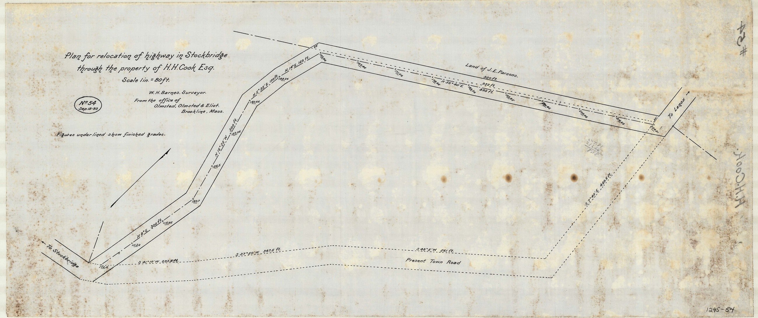
Plan 54 shows both roads on one sheet. The existing way is a dotted line running low across the property. The replacement is drawn solid, swung north and uphill, meeting the old alignments at the two ends — marked, in the draftsman's hand, To Stockbridge at one and To Lenox at the other. The land north of the new line is labeled as belonging to J.E. Parsons.
A note reads, “Figures underlined show finished grades.” This was not a proposal sketched for discussion. It was a construction drawing.
I A Small Point of Local Procedure
A private landowner cannot move a public way. A town can, and towns did — regularly, and usually for good reason, since a road laid out in the eighteenth century often ran where nobody in the nineteenth wanted it. What a landowner can do is pay for the survey, produce the plans, and put the question.
Plan 53 carries the phrase “Description Voted Aug-1892”, which suggests the town had already acted on something before these sheets were drawn. What the Stockbridge town meeting actually voted, when, and on what terms is in the town records and not in the Olmsted archive. It is the obvious next thing to look up, and anyone with an afternoon and the Town Clerk's index can settle it.
One detail is worth keeping: the surveyor who drew the relocation, W.H. Barnes of Housatonic, is the same man who had measured the Gideon Smith farm in 1886, before any of this existed. He surveyed the farm, and then he helped move the road off it.
II Then They Planted It
This is the part that makes it a landscape story rather than a paperwork story.
Plan 84, dated 3 March 1894, and plan 122, dated the following October, carry circled numbers along both sides of the new road, running south-west from the entrance gate. Read against the planting list lettered on plan 84 itself, the sequence is:
44 · 20 · 44 · 47 · 44 · 48 · 44
Shadbush, redbud, shadbush, pagoda dogwood, shadbush, silver maple, shadbush. A repeat with three variations threaded through it — all small flowering trees except the maple, all white and pink in April and May, on a public road that had not existed eighteen months earlier.
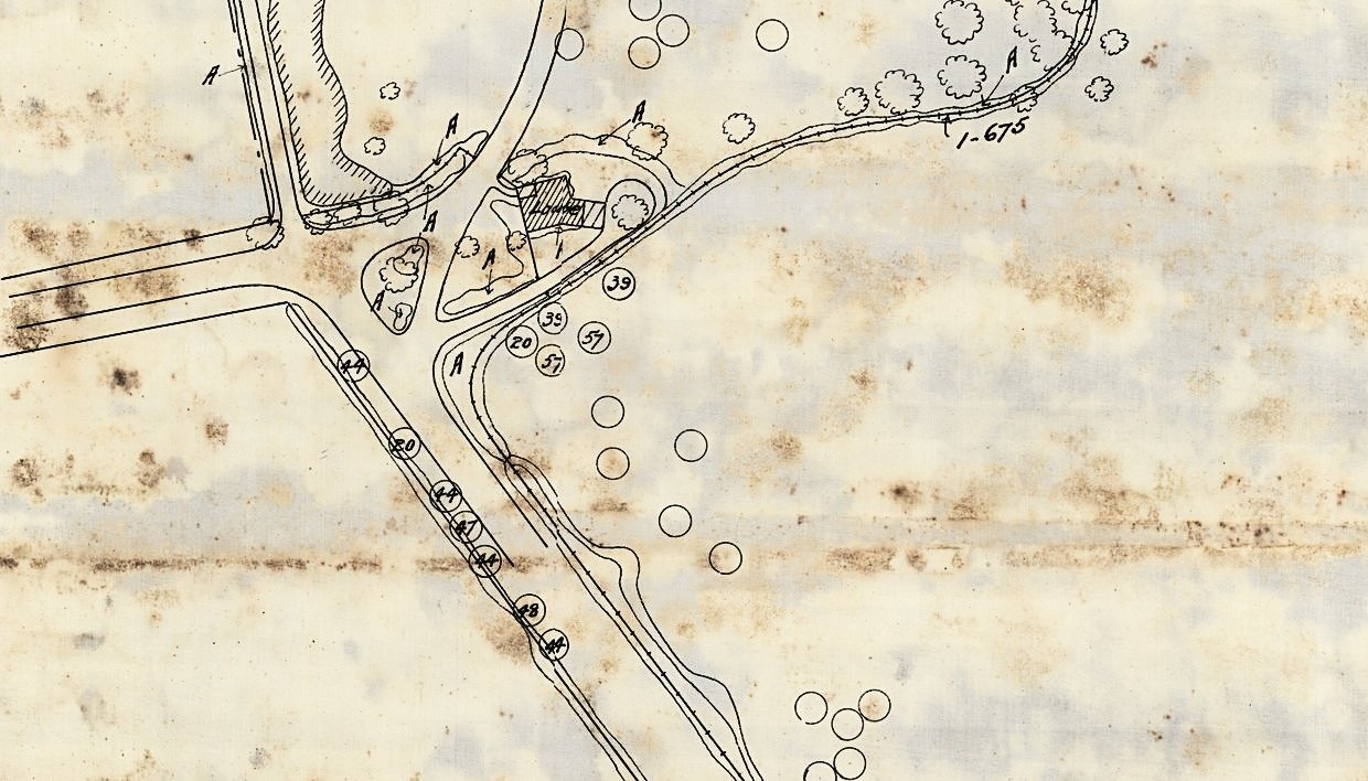
At the gate the numbers cluster: two flowering dogwoods, a redbud, and two American elms. Behind them, falling away from the lodge, a scatter of dogwood, striped maple and more elm. On the older sheet for the lodge, drawn in October 1893, the elms are marked simply — Elm — one in each of two islands at the fork.
III And Most of It Was Already In
Plan 84 carries a note in the lower corner that is easy to walk past. It reads, in full:
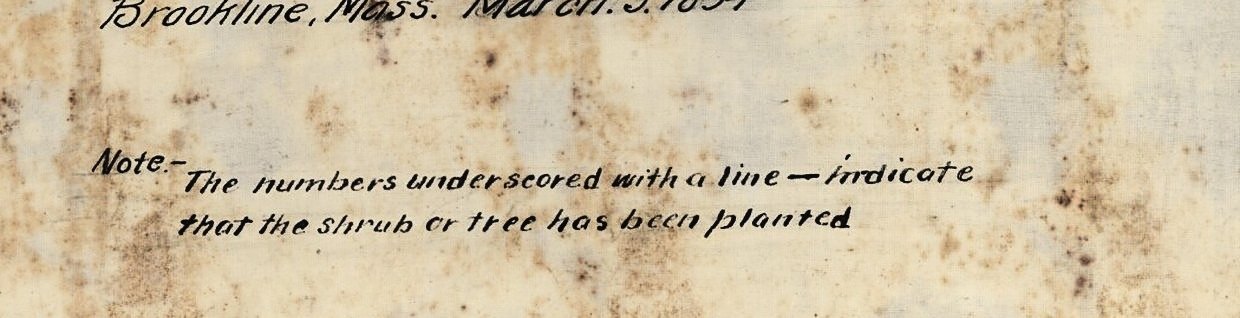
At the gate, most of them are underscored. Which means the trees along the relocated road went into the ground during the autumn of 1893, within weeks of the road being laid out — and that the drawings we have are not only a record of what a famous office intended, but of what a crew with shovels actually did, and when.
There is no separate document that says so. It is a pencil line under a number in a circle, on a linen sheet, in a federal archive, where it has been legible and unread for a hundred and thirty-two years.
IV What to Look For
Whether the road in use today follows the 1893 line depends where you stand. The alignments converge at the ends and diverge through the descent, so the stretch at the top of the hill is the old way and the stretch below it is Cook's. An overlay and a walk will fix the join.
The same goes for the trees. Shadbush is short-lived and the elms are gone, but silver maple and pagoda dogwood persist, and a repeating rhythm of anything along a roadside is a planted rhythm.
Next time you drive it, count.
Sources: Olmsted Archives, Frederick Law Olmsted National Historic Site, job #01295, plans 1, 52, 53, 54, 73, 75, 84 and 122-sh1. Note: Olmsted Online dates plan 54 to February 1893; the sheet itself reads Sep 18-93, consistent with the two sheets either side of it. Images courtesy of the United States Department of the Interior, National Park Service, Frederick Law Olmsted National Historic Site.